Poster Print > Arts > Artists > H > Jodocus Hondius
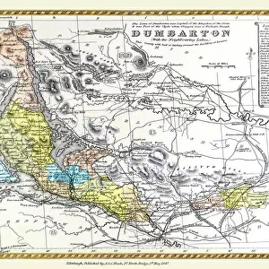
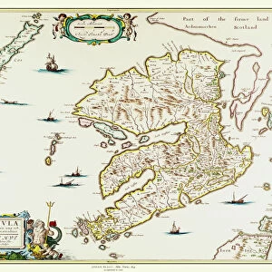
Poster Print : Old Map of the Isle of Mull Scotland 1654 by Johan Blaue from the Atlas Novus


![]()
Poster Prints from MapSeeker
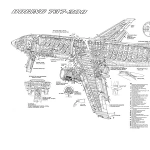
Old Map of the Isle of Mull Scotland 1654 by Johan Blaue from the Atlas Novus
This detailed and most attractive reproduction map of The Isle of Mull has been carefully art worked from a scan of an antique original. The famous firm of Dutch cartographers and publishers was established in the late 16th century by Willem Janszoon Blaeu in Amsterdam. Blaeu was a maker of globes and scientific instruments and purchased some of his early map plates from Jodocus Hondius. From this small beginning was to emerge one of the largest and most prolific map publishing houses of the seventeenth century
Welcome to the Mapseeker Image library and enter an historic gateway to one of the largest on-line collections of Historic Maps, Nostalgic Views, Vista's and Panorama's from a World gone by.
Media ID 20347864
Blaeu Blaeu Family Blaue Map Historic Map Johan Blaeu Johan Blaeu Map Old Blaue Map Isle Of Mull
18x24 inch Poster Print
Discover the rich history of Scotland's enchanting Isle of Mull with our exquisite Old Map Print from Media Storehouse. This captivating reproduction, sourced from the Atlas Novus by Johan Blaue in 1654, showcases intricate details of the island's geography, villages, and landmarks as they appeared over 300 years ago. Meticulously art-worked from a high-resolution scan of an original antique map, our Old Map of the Isle of Mull is a stunning addition to any home or office, evoking a sense of nostalgia and wonder. Bring a piece of Scotland's rich past into your space and embellish your walls with this beautiful, historic map print.
Poster prints are budget friendly enlarged prints in standard poster paper sizes. Printed on 150 gsm Matte Paper for a natural feel and supplied rolled in a tube. Great for framing and should last many years. To clean wipe with a microfiber, non-abrasive cloth or napkin. Our Archival Quality Photo Prints and Fine Art Paper Prints are printed on higher quality paper and the choice of which largely depends on your budget.
Poster prints are budget friendly enlarged prints in standard poster paper sizes (A0, A1, A2, A3 etc). Whilst poster paper is sometimes thinner and less durable than our other paper types, they are still ok for framing and should last many years. Our Archival Quality Photo Prints and Fine Art Paper Prints are printed on higher quality paper and the choice of which largely depends on your budget.
Estimated Product Size is 61.6cm x 46.3cm (24.3" x 18.2")
These are individually made so all sizes are approximate
Artwork printed orientated as per the preview above, with landscape (horizontal) orientation to match the source image.
FEATURES IN THESE COLLECTIONS
> MapSeeker
> Maps from the British Isles
> Scotland and Counties PORTFOLIO
> Arts
> Artists
> B
> Willem Blaeu
> Arts
> Artists
> H
> Jodocus Hondius
> Arts
> Photorealistic artworks
> Detailed art pieces
> Masterful detailing in art
> Europe
> United Kingdom
> Scotland
> Maps
> Europe
> United Kingdom
> Scotland
> Posters
> Europe
> United Kingdom
> Scotland
> Related Images
> Maps and Charts
> Early Maps
> Maps and Charts
> Related Images
> Maps and Charts
> Willem Janszoon Blaeu
EDITORS COMMENTS
This beautifully detailed reproduction of Johan Blaue's "Old Map of the Isle of Mull Scotland 1654" takes us back in time to explore the historical landscape of this enchanting Scottish island. Carefully art worked from a scan of an antique original, this map captures the intricate craftsmanship and attention to detail that made Blaue's maps so renowned. The Blaeu family, pioneers in cartography and publishing during the seventeenth century, established their firm in Amsterdam under the guidance of Willem Janszoon Blaeu. Originally a maker of globes and scientific instruments, Blaeu ventured into mapmaking by acquiring some plates from Jodocus Hondius. Little did he know that his humble beginnings would lead to one of the largest and most prolific map publishing houses at that time. As we gaze upon this historic map, we can almost feel ourselves stepping into another era. The Isle of Mull comes alive with its rugged coastlines, rolling hills, and charming villages depicted with meticulous precision. This glimpse into history allows us to appreciate how much has changed over centuries while also recognizing the enduring beauty and allure that still captivates visitors today. Whether you are a history enthusiast or simply drawn to vintage aesthetics, this old map offers a fascinating window into the past. It serves as a reminder that even amidst our modern world, there is always value in exploring our roots and discovering the stories embedded within these ancient landscapes.
MADE IN THE USA
Safe Shipping with 30 Day Money Back Guarantee
FREE PERSONALISATION*
We are proud to offer a range of customisation features including Personalised Captions, Color Filters and Picture Zoom Tools
SECURE PAYMENTS
We happily accept a wide range of payment options so you can pay for the things you need in the way that is most convenient for you
* Options may vary by product and licensing agreement. Zoomed Pictures can be adjusted in the Cart.