Poster Print > Maps and Charts > Related Images
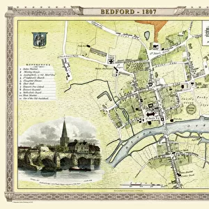
Poster Print : Old Map of Rushall to Daw End near Walsall 1888


![]()
Poster Prints from MapSeeker
Old Map of Rushall to Daw End near Walsall 1888
PL011
Welcome to the Mapseeker Image library and enter an historic gateway to one of the largest on-line collections of Historic Maps, Nostalgic Views, Vista's and Panorama's from a World gone by.
Media ID 20348241
18x24 inch Poster Print
Step back in time with our Old Map of Rushall to Daw End near Walsall 1888 (PL011) from Media Storehouse's Poster Prints collection. This captivating vintage map, sourced from MapSeeker, transports you back over a century ago. Ideal for enhancing the decor of your home office, study, or even a cozy reading nook, this beautifully printed poster is a must-have for history enthusiasts and locals. Bring a piece of the past into your present with Media Storehouse's Old Map of Rushall to Daw End near Walsall 1888 (PL011) Poster Print.
Poster prints are budget friendly enlarged prints in standard poster paper sizes. Printed on 150 gsm Matte Paper for a natural feel and supplied rolled in a tube. Great for framing and should last many years. To clean wipe with a microfiber, non-abrasive cloth or napkin. Our Archival Quality Photo Prints and Fine Art Paper Prints are printed on higher quality paper and the choice of which largely depends on your budget.
Poster prints are budget friendly enlarged prints in standard poster paper sizes (A0, A1, A2, A3 etc). Whilst poster paper is sometimes thinner and less durable than our other paper types, they are still ok for framing and should last many years. Our Archival Quality Photo Prints and Fine Art Paper Prints are printed on higher quality paper and the choice of which largely depends on your budget.
Estimated Product Size is 46.3cm x 61.6cm (18.2" x 24.3")
These are individually made so all sizes are approximate
Artwork printed orientated as per the preview above, with portrait (vertical) orientation to match the source image.
FEATURES IN THESE COLLECTIONS
> MapSeeker
> British Town And City Plans
> English & Welsh PORTFOLIO
> Maps and Charts
> Related Images
EDITORS COMMENTS
This print showcases an exquisite piece of history, the "Old Map of Rushall to Daw End near Walsall 1888 (PL011)". Transporting us back in time, this historic map offers a fascinating glimpse into the past. With intricate details and delicate craftsmanship, it serves as a testament to the artistry and precision of cartography in the late 19th century. The map specifically focuses on Rushall village, nestled near Walsall in England. Its carefully drawn lines trace the streets and landmarks that once defined this quaint community. Every corner is meticulously labeled, allowing us to envision how life unfolded within these boundaries over a century ago. As we explore this vintage treasure, our imagination runs wild with stories from bygone eras. We can almost hear the bustling sounds of horse-drawn carriages echoing through its narrow lanes or picture villagers going about their daily routines amidst charming cottages and local shops. While admiring this remarkable piece of history, let's appreciate its significance beyond commercial use. Let's cherish it for what it truly represents: a tangible connection to our heritage and an opportunity to reflect upon how far we have come since those days gone by. Whether you are a history enthusiast or simply captivated by antiquity, this old map of Rushall Village will undoubtedly transport you back in time – inviting you to walk alongside generations long past while marveling at their world preserved on paper.
MADE IN THE USA
Safe Shipping with 30 Day Money Back Guarantee
FREE PERSONALISATION*
We are proud to offer a range of customisation features including Personalised Captions, Color Filters and Picture Zoom Tools
SECURE PAYMENTS
We happily accept a wide range of payment options so you can pay for the things you need in the way that is most convenient for you
* Options may vary by product and licensing agreement. Zoomed Pictures can be adjusted in the Cart.