Poster Print > Arts > Artists > B > Joan Blaeu
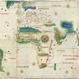
Poster Print : Double hemisphere map of the World. Artist: Blaeu, Joan (1596-1673)
")

![]()
Poster Prints From Heritage Images
Double hemisphere map of the World. Artist: Blaeu, Joan (1596-1673)
Double hemisphere map of the World. Private Collection
Heritage Images features heritage image collections
Media ID 15017210
© Fine Art Images
Blaeu Cartography Map Of The World Maps The Netherlands World Map Atlas Maior
18x24 inch Poster Print
Discover the fascinating history of cartography with our exclusive Media Storehouse Poster Print of the Double Hemisphere Map of the World. This stunning vintage map, created by renowned cartographer Joan Blaeu in 1673, offers a unique representation of the world as seen from both the Northern and Southern hemispheres. Each half of the map is intricately detailed, showcasing the known lands and waters of the time. A must-have for history enthusiasts, educators, and anyone with an appreciation for the beauty and evolution of cartography. Bring a piece of the past into your modern home or office with this beautiful, museum-quality poster print from Heritage Images.
Poster prints are budget friendly enlarged prints in standard poster paper sizes. Printed on 150 gsm Matte Paper for a natural feel and supplied rolled in a tube. Great for framing and should last many years. To clean wipe with a microfiber, non-abrasive cloth or napkin. Our Archival Quality Photo Prints and Fine Art Paper Prints are printed on higher quality paper and the choice of which largely depends on your budget.
Poster prints are budget friendly enlarged prints in standard poster paper sizes (A0, A1, A2, A3 etc). Whilst poster paper is sometimes thinner and less durable than our other paper types, they are still ok for framing and should last many years. Our Archival Quality Photo Prints and Fine Art Paper Prints are printed on higher quality paper and the choice of which largely depends on your budget.
Estimated Product Size is 61.6cm x 46.3cm (24.3" x 18.2")
These are individually made so all sizes are approximate
Artwork printed orientated as per the preview above, with landscape (horizontal) orientation to match the source image.
FEATURES IN THESE COLLECTIONS
> Arts
> Artists
> B
> Joan Blaeu
> Europe
> Netherlands
> Maps
> Europe
> Netherlands
> Posters
> Europe
> Netherlands
> Related Images
> Maps and Charts
> Netherlands
> Maps and Charts
> Related Images
> Maps and Charts
> World
EDITORS COMMENTS
This print showcases a remarkable piece of cartographic artistry - the Double Hemisphere Map of the World by Joan Blaeu. Crafted in the 17th century, this exquisite map is a testament to Blaeu's mastery as a cartographer and his contribution to the field of geography. The map itself is divided into two hemispheres, each meticulously detailed with intricate etchings and vibrant watercolors. It offers an intriguing glimpse into how people perceived the world during that era, with its depiction of continents, oceans, and even mythical creatures believed to inhabit unexplored territories. Blaeu's attention to detail is evident in every corner of this masterpiece. From delicate lines tracing coastlines to carefully labeled cities and landmarks, it reflects not only his expertise but also his dedication to accuracy. This particular print comes from a private collection, adding an air of exclusivity and rarity. As we admire this historic artifact, we are transported back in time - immersing ourselves in an age when exploration was at its peak and knowledge about our planet was expanding rapidly. The Double Hemisphere Map serves as both a historical document and a work of art; it encapsulates centuries worth of discoveries while showcasing Blaeu's artistic flair. Whether you are fascinated by history or simply appreciate fine art images, this print allows you to own a piece of cartographic heritage that will undoubtedly spark curiosity and admiration for generations to come.
MADE IN THE USA
Safe Shipping with 30 Day Money Back Guarantee
FREE PERSONALISATION*
We are proud to offer a range of customisation features including Personalised Captions, Color Filters and Picture Zoom Tools
SECURE PAYMENTS
We happily accept a wide range of payment options so you can pay for the things you need in the way that is most convenient for you
* Options may vary by product and licensing agreement. Zoomed Pictures can be adjusted in the Basket.