Poster Print > Europe > France > Maps
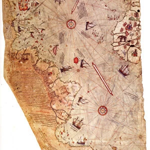
Poster Print : Carta Pisana, ca 1275-1300. Artist: Anonymous master

Poster Prints From Heritage Images
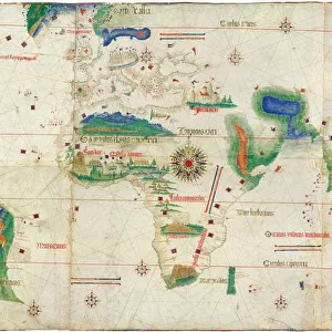
Carta Pisana, ca 1275-1300. Artist: Anonymous master
Carta Pisana, ca 1275-1300. Found in the collection of the Bibliotheque Nationale de France
Heritage Images features heritage image collections
Media ID 15015616
© Fine Art Images
Anonymous Master Cartography Chart Ink On Parchment Nautical Chart Portolan Portolan Chart
20x30 inch Poster Print
Discover the rich history of cartography with our exquisite selection of Media Storehouse Poster Prints. Feast your eyes on this stunningly detailed depiction of the "Carta Pisana," an anonymous masterpiece from the late 13th century. Originating from the Bibliotheque Nationale de France, this captivating map showcases the intricate details of the Mediterranean world as it was known during the Middle Ages. Transport yourself back in time and adorn your walls with this beautiful piece of historical artistry.
Poster prints are budget friendly enlarged prints in standard poster paper sizes. Printed on 150 gsm Matte Paper for a natural feel and supplied rolled in a tube. Great for framing and should last many years. To clean wipe with a microfiber, non-abrasive cloth or napkin. Our Archival Quality Photo Prints and Fine Art Paper Prints are printed on higher quality paper and the choice of which largely depends on your budget.
Poster prints are budget friendly enlarged prints in standard poster paper sizes (A0, A1, A2, A3 etc). Whilst poster paper is sometimes thinner and less durable than our other paper types, they are still ok for framing and should last many years. Our Archival Quality Photo Prints and Fine Art Paper Prints are printed on higher quality paper and the choice of which largely depends on your budget.
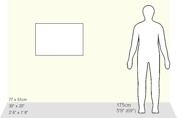
Estimated Product Size is 76.8cm x 51.4cm (30.2" x 20.2")
These are individually made so all sizes are approximate
Artwork printed orientated as per the preview above, with landscape (horizontal) or portrait (vertical) orientation to match the source image.
FEATURES IN THESE COLLECTIONS
> Maps and Charts
> Related Images
EDITORS COMMENTS
This print showcases the remarkable Carta Pisana, a masterpiece of cartography created by an anonymous master between 1275 and 1300. Housed in the prestigious collection of the Bibliotheque Nationale de France, this ancient nautical chart is a testament to the ingenuity and precision of early mapmakers. Rendered meticulously with ink on parchment, every intricate detail comes to life in this fine art image. The Carta Pisana offers a glimpse into history, transporting us back to an era when seafaring was both treacherous and adventurous. Its purpose as a navigational tool for sailors becomes evident through its carefully plotted coastlines, ports, and sea routes. As we delve deeper into this portolan chart's composition, we are captivated by its graphic arts elements that seamlessly blend practicality with aesthetic beauty. Each stroke tells a story of exploration and discovery; each contour represents countless journeys across uncharted waters. The anonymity of the artist only adds to the mystique surrounding this extraordinary piece. Their skillful craftsmanship has stood the test of time, leaving behind an enduring legacy that continues to inspire contemporary cartographers. This print serves as a reminder not only of our shared human history but also of our innate curiosity about the world around us. It invites us to marvel at how knowledge was once painstakingly recorded on such delicate materials like parchment—a true testament to human perseverance and intellectual prowess.
MADE IN THE USA
Safe Shipping with 30 Day Money Back Guarantee
FREE PERSONALISATION*
We are proud to offer a range of customisation features including Personalised Captions, Color Filters and Picture Zoom Tools
SECURE PAYMENTS
We happily accept a wide range of payment options so you can pay for the things you need in the way that is most convenient for you
* Options may vary by product and licensing agreement. Zoomed Pictures can be adjusted in the Basket.