Poster Print > North America > United States of America > New York > New York > Maps
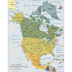
Poster Print : Political Map of North America 1895


![]()
Poster Prints From Fine Art Storehouse
Political Map of North America 1895
The Rand-McNally Grammar School Geography 1895 - Chicago & New York
Unleash your creativity and transform your space into a visual masterpiece!
THEPALMER
Media ID 14824607
© This content is subject to copyright
Canada Caribbean Mexico United States
18x24 inch Poster Print
Discover history with our captivating Political Map of North America 1895 by THEPALMER from Media Storehouse's Fine Art Storehouse collection. This vintage print, originally published by Rand-McNally for their Grammar School Geography series in 1895, offers a fascinating glimpse into the political landscape of the time. With intricate details and vibrant colors, this map beautifully illustrates the political boundaries, territories, and names of countries and regions in North America during the late 19th century. Add this unique piece to your collection and transport yourself back in time, making for an excellent conversation starter and a beautiful addition to any wall.
Poster prints are budget friendly enlarged prints in standard poster paper sizes. Printed on 150 gsm Matte Paper for a natural feel and supplied rolled in a tube. Great for framing and should last many years. To clean wipe with a microfiber, non-abrasive cloth or napkin. Our Archival Quality Photo Prints and Fine Art Paper Prints are printed on higher quality paper and the choice of which largely depends on your budget.
Poster prints are budget friendly enlarged prints in standard poster paper sizes (A0, A1, A2, A3 etc). Whilst poster paper is sometimes thinner and less durable than our other paper types, they are still ok for framing and should last many years. Our Archival Quality Photo Prints and Fine Art Paper Prints are printed on higher quality paper and the choice of which largely depends on your budget.
Estimated Product Size is 46.3cm x 61.6cm (18.2" x 24.3")
These are individually made so all sizes are approximate
Artwork printed orientated as per the preview above, with portrait (vertical) orientation to match the source image.
FEATURES IN THESE COLLECTIONS
> Fine Art Storehouse
> Map
> Historical Maps
> Fine Art Storehouse
> Map
> USA Maps
> Arts
> Artists
> M
> Mexican School Mexican School
> Maps and Charts
> Related Images
> North America
> Canada
> Maps
> North America
> Canada
> Related Images
> North America
> Mexico
> Related Images
> North America
> United States of America
> Maps
> North America
> United States of America
> New Mexico
> Related Images
> North America
> United States of America
> New York
> New York
> Maps
> North America
> United States of America
> New York
> Related Images
EDITORS COMMENTS
In this print titled "Political Map of North America 1895" we are transported back in time to the late 19th century, when cartography was a meticulous art form. The map, sourced from "The Rand-McNally Grammar School Geography 1895" publication, takes us on a visual journey across the vast expanse of North America. With its intricate details and delicate coloring, the map showcases an era where geographical boundaries were still evolving. From the sprawling United States to Canada's expansive territories and Mexico's vibrant landscapes, every inch of this continent is meticulously depicted. As our eyes wander over this vintage masterpiece, we can't help but notice how much has changed since that time. The Caribbean islands stand out like gems amidst the azure waters while Central American countries proudly display their unique identities. It serves as a reminder of both historical events and cultural diversity that have shaped these lands over centuries. "The Political Map of North America 1895" by THEPALMER captures not only geographic information but also offers a glimpse into the past – an invaluable resource for historians and enthusiasts alike. This print from Fine Art Storehouse allows us to appreciate the craftsmanship involved in creating such maps while igniting our curiosity about how different nations have evolved throughout history.
MADE IN THE USA
Safe Shipping with 30 Day Money Back Guarantee
FREE PERSONALISATION*
We are proud to offer a range of customisation features including Personalised Captions, Color Filters and Picture Zoom Tools
SECURE PAYMENTS
We happily accept a wide range of payment options so you can pay for the things you need in the way that is most convenient for you
* Options may vary by product and licensing agreement. Zoomed Pictures can be adjusted in the Basket.