Poster Print > Europe > Italy > Maps
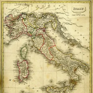
Poster Print : Map of Italy 1900


![]()
Poster Prints From Fine Art Storehouse
Map of Italy 1900
Meyers hand-Atlas Leipzig und Wien Verlag des Bibliographischen Instituts 1900
Unleash your creativity and transform your space into a visual masterpiece!
THEPALMER
Media ID 18106855
© 2014 Roberto Adrian Photography
18x24 inch Poster Print
Step back in time with our exquisite Map of Italy 1900 poster print from THEPALMER at Media Storehouse. This captivating piece is taken from the esteemed Meyers Hand-Atlas published by the Bibliographisches Institut in Leipzig and Wien in 1900. With intricate details and vibrant colors, this vintage map provides a fascinating glimpse into the historical geography of Italy during the early 20th century. Bring a touch of the past into your home or office and transport yourself on a journey through time with this beautifully preserved piece of cartographical history.
Poster prints are budget friendly enlarged prints in standard poster paper sizes. Printed on 150 gsm Matte Paper for a natural feel and supplied rolled in a tube. Great for framing and should last many years. To clean wipe with a microfiber, non-abrasive cloth or napkin. Our Archival Quality Photo Prints and Fine Art Paper Prints are printed on higher quality paper and the choice of which largely depends on your budget.
Poster prints are budget friendly enlarged prints in standard poster paper sizes (A0, A1, A2, A3 etc). Whilst poster paper is sometimes thinner and less durable than our other paper types, they are still ok for framing and should last many years. Our Archival Quality Photo Prints and Fine Art Paper Prints are printed on higher quality paper and the choice of which largely depends on your budget.
Estimated Product Size is 46.3cm x 61.6cm (18.2" x 24.3")
These are individually made so all sizes are approximate
Artwork printed orientated as per the preview above, with portrait (vertical) orientation to match the source image.
FEATURES IN THESE COLLECTIONS
> Fine Art Storehouse
> Map
> Historical Maps
> Fine Art Storehouse
> Map
> Italian Maps
> Maps and Charts
> Italy
EDITORS COMMENTS
In this print titled "Map of Italy 1900" we are transported back in time to the turn of the century. The map, sourced from Meyers hand-Atlas Leipzig und Wien Verlag des Bibliographischen Instituts in 1900, offers a fascinating glimpse into Italy's geographical landscape during that era. The intricate details and meticulous craftsmanship of this vintage map immediately catch our attention. Every contour, river, and city is delicately marked with precision, showcasing the cartographer's dedication to accuracy. As we explore the different regions depicted on the map, it becomes evident how much Italy has evolved over time. This historical snapshot allows us to appreciate both the beauty and complexity of Italy's diverse topography. From its majestic Alps in the north to its sun-kissed shores along the Mediterranean Sea, every corner seems to hold a story waiting to be discovered. Beyond its aesthetic appeal, this print also serves as a reminder of how maps have played an essential role in shaping our understanding of geography throughout history. It invites us to reflect on how far we have come in terms of technological advancements and mapping techniques since 1900. "The Map of Italy 1900" by THEPALMER is not just a piece for art enthusiasts but also for those who appreciate history and culture. It sparks curiosity about our past while simultaneously igniting wanderlust for exploring present-day Italy – a country rich in heritage and charm.
MADE IN THE USA
Safe Shipping with 30 Day Money Back Guarantee
FREE PERSONALISATION*
We are proud to offer a range of customisation features including Personalised Captions, Color Filters and Picture Zoom Tools
SECURE PAYMENTS
We happily accept a wide range of payment options so you can pay for the things you need in the way that is most convenient for you
* Options may vary by product and licensing agreement. Zoomed Pictures can be adjusted in the Basket.