Poster Print > Africa > Madagascar > Maps
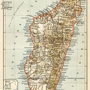
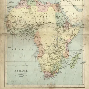
Poster Print : Topografic map of Madagascar, lithograph, published in 1897


![]()
Poster Prints from Fine Art Storehouse
Topografic map of Madagascar, lithograph, published in 1897
Topografic map of Madagascar. Lithograph, published in 1897
Unleash your creativity and transform your space into a visual masterpiece!
ZU_09
Media ID 18106991
18x24 inch Poster Print
"Discover the rich history and geography of Madagascar with our stunning Topografic Map of Madagascar print from the Media Storehouse Fine Art Collection. This beautiful lithograph, published in 1897, offers a captivating glimpse into the past with intricate detail and precise cartography. Perfect for the explorer, historian, or anyone with a love for vintage maps, this unique piece adds an air of adventure and sophistication to any space. Bring a piece of the past into your home or office with the Topografic Map of Madagascar from Media Storehouse Fine Art Storehouse."
Poster prints are budget friendly enlarged prints in standard poster paper sizes. Printed on 150 gsm Matte Paper for a natural feel and supplied rolled in a tube. Great for framing and should last many years. To clean wipe with a microfiber, non-abrasive cloth or napkin. Our Archival Quality Photo Prints and Fine Art Paper Prints are printed on higher quality paper and the choice of which largely depends on your budget.
Poster prints are budget friendly enlarged prints in standard poster paper sizes (A0, A1, A2, A3 etc). Whilst poster paper is sometimes thinner and less durable than our other paper types, they are still ok for framing and should last many years. Our Archival Quality Photo Prints and Fine Art Paper Prints are printed on higher quality paper and the choice of which largely depends on your budget.
Estimated Product Size is 46.3cm x 61.6cm (18.2" x 24.3")
These are individually made so all sizes are approximate
Artwork printed orientated as per the preview above, with portrait (vertical) orientation to match the source image.
FEATURES IN THESE COLLECTIONS
> Fine Art Storehouse
> Map
> Historical Maps
> Africa
> Madagascar
> Maps
> Africa
> Madagascar
> Related Images
> Maps and Charts
> Related Images
EDITORS COMMENTS
This lithograph, titled "Topographic Map of Madagascar" takes us on a journey back in time to the year 1897. Created by the talented artist ZU_09, this print showcases an exquisite level of detail and precision that was characteristic of cartography during that era. The map itself is a testament to the artistry and scientific accuracy employed by early explorers and geographers. With intricate lines, symbols, and shading techniques, it beautifully depicts the topography of Madagascar - an island known for its diverse landscapes ranging from lush rainforests to towering mountains. As we gaze upon this vintage masterpiece, we are transported into an age where maps were not just tools for navigation but also works of art. The lithograph's sepia tones evoke a sense of nostalgia while adding depth and richness to every contour line etched onto the paper. Beyond its aesthetic appeal, this map serves as a historical document that sheds light on how our understanding of geography has evolved over time. It reminds us that long before satellite imagery or digital mapping systems existed, skilled artisans like ZU_09 painstakingly crafted these visual representations using traditional methods. Whether you're an avid collector or simply appreciate the beauty found in old-world craftsmanship, this "Topographic Map of Madagascar" lithograph offers both artistic delight and a glimpse into history's cartographic past.
MADE IN THE USA
Safe Shipping with 30 Day Money Back Guarantee
FREE PERSONALISATION*
We are proud to offer a range of customisation features including Personalised Captions, Color Filters and Picture Zoom Tools
SECURE PAYMENTS
We happily accept a wide range of payment options so you can pay for the things you need in the way that is most convenient for you
* Options may vary by product and licensing agreement. Zoomed Pictures can be adjusted in the Cart.