Poster Print > Asia > Philippines > Maps
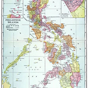
Poster Print : Philippines islands map 1898


![]()
Poster Prints From Fine Art Storehouse
Philippines islands map 1898
Unleash your creativity and transform your space into a visual masterpiece!
THEPALMER
Media ID 14756928
© This content is subject to copyright
18x24 inch Poster Print
Discover the rich history of the Philippines with our exquisite poster print of the Philippines Islands Map from 1898, by THEPALMER from our Media Storehouse Fine Art Collection. This captivating vintage map showcases the islands of the Philippines as they appeared during the Spanish colonial era, offering a fascinating glimpse into the past. Add an element of history and culture to your space with this beautifully detailed and intricately designed map print. Perfect for home offices, classrooms, or any room seeking a touch of nostalgia and adventure.
Poster prints are budget friendly enlarged prints in standard poster paper sizes. Printed on 150 gsm Matte Paper for a natural feel and supplied rolled in a tube. Great for framing and should last many years. To clean wipe with a microfiber, non-abrasive cloth or napkin. Our Archival Quality Photo Prints and Fine Art Paper Prints are printed on higher quality paper and the choice of which largely depends on your budget.
Poster prints are budget friendly enlarged prints in standard poster paper sizes (A0, A1, A2, A3 etc). Whilst poster paper is sometimes thinner and less durable than our other paper types, they are still ok for framing and should last many years. Our Archival Quality Photo Prints and Fine Art Paper Prints are printed on higher quality paper and the choice of which largely depends on your budget.
Estimated Product Size is 46.3cm x 61.6cm (18.2" x 24.3")
These are individually made so all sizes are approximate
Artwork printed orientated as per the preview above, with portrait (vertical) orientation to match the source image.
FEATURES IN THESE COLLECTIONS
> Fine Art Storehouse
> Map
> Historical Maps
> Asia
> Philippines
> Maps
> Asia
> Philippines
> Related Images
> Maps and Charts
> Related Images
EDITORS COMMENTS
This print titled "Philippines islands map 1898" takes us on a journey back in time to the year when the Philippines was under American rule. The intricate details and historical significance of this map make it a true gem for history enthusiasts and art lovers alike. The image showcases an exquisite reproduction of the original 1898 map, meticulously crafted by THEPALMER. Every contour, coastline, and island is beautifully depicted, offering a glimpse into the archipelago's geography during that era. The fine lines and delicate shading bring out the rich topography of these enchanting islands. As we gaze upon this piece, our imagination transports us to a time when colonial powers were shaping the destiny of nations. It serves as a reminder of how borders have evolved over time and how cultures have intertwined within these lands. The artist's attention to detail is evident in every stroke, capturing not only geographical accuracy but also evoking emotions associated with exploration and discovery. This artwork invites viewers to delve deeper into Philippine history while appreciating its aesthetic appeal. Whether displayed in homes or educational institutions, this print from Fine Art Storehouse sparks conversations about heritage, identity, and our collective past. It stands as both an artistic masterpiece and an invaluable historical artifact that connects us with our roots.
MADE IN THE USA
Safe Shipping with 30 Day Money Back Guarantee
FREE PERSONALISATION*
We are proud to offer a range of customisation features including Personalised Captions, Color Filters and Picture Zoom Tools
SECURE PAYMENTS
We happily accept a wide range of payment options so you can pay for the things you need in the way that is most convenient for you
* Options may vary by product and licensing agreement. Zoomed Pictures can be adjusted in the Basket.