Poster Print > Maps and Charts > Related Images
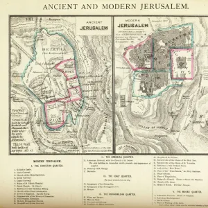
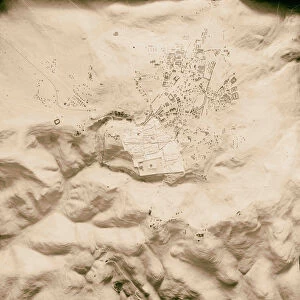
Poster Print : Map of Jerusalem 1895


![]()
Poster Prints From Fine Art Storehouse
Map of Jerusalem 1895
Illustration of a Map of Jerusalem
Unleash your creativity and transform your space into a visual masterpiece!
Nastasic
Media ID 14756828
© This content is subject to copyright
18x24 inch Poster Print
Step back in time with our exquisite Map of Jerusalem 1895 print from the Media Storehouse Fine Art collection. This captivating reproduction showcases the intricate details of Nastasic's historic map of the Holy City, transporting you back to an era of rich history and cultural significance. Perfect for enhancing your home or office decor, this high-quality poster print brings a piece of the past into your present. Experience the allure of Jerusalem like never before with our authentic and beautifully crafted fine art print.
Poster prints are budget friendly enlarged prints in standard poster paper sizes. Printed on 150 gsm Matte Paper for a natural feel and supplied rolled in a tube. Great for framing and should last many years. To clean wipe with a microfiber, non-abrasive cloth or napkin. Our Archival Quality Photo Prints and Fine Art Paper Prints are printed on higher quality paper and the choice of which largely depends on your budget.
Poster prints are budget friendly enlarged prints in standard poster paper sizes (A0, A1, A2, A3 etc). Whilst poster paper is sometimes thinner and less durable than our other paper types, they are still ok for framing and should last many years. Our Archival Quality Photo Prints and Fine Art Paper Prints are printed on higher quality paper and the choice of which largely depends on your budget.
Estimated Product Size is 46.3cm x 61.6cm (18.2" x 24.3")
These are individually made so all sizes are approximate
Artwork printed orientated as per the preview above, with portrait (vertical) orientation to match the source image.
EDITORS COMMENTS
This print showcases a remarkable piece of history, the "Map of Jerusalem 1895" by Nastasic. With its intricate details and artistic flair, this illustration takes us on a journey back in time to the vibrant cityscape of Jerusalem over a century ago. The map's exquisite craftsmanship is evident in every stroke, capturing the essence of this ancient city with precision and elegance. From the winding streets to the majestic landmarks, it offers a window into an era long gone but not forgotten. As we gaze upon this masterpiece, our eyes are drawn to each carefully labeled street and building, allowing us to explore Jerusalem's rich tapestry of culture and heritage. The artist has expertly portrayed the diverse architectural styles that coexist harmoniously within these walls - from grand palaces to humble dwellings. Beyond its aesthetic appeal, this map serves as an invaluable historical document. It provides insights into how Jerusalem evolved throughout time while preserving its timeless charm. It reminds us that beneath layers of modernization lies a city steeped in tradition and spirituality. Whether you're an art enthusiast or history buff, this print is sure to captivate your imagination. Displaying it proudly in your home or office will not only add sophistication but also spark conversations about one of humanity's most cherished cities – Jerusalem.
MADE IN THE USA
Safe Shipping with 30 Day Money Back Guarantee
FREE PERSONALISATION*
We are proud to offer a range of customisation features including Personalised Captions, Color Filters and Picture Zoom Tools
SECURE PAYMENTS
We happily accept a wide range of payment options so you can pay for the things you need in the way that is most convenient for you
* Options may vary by product and licensing agreement. Zoomed Pictures can be adjusted in the Basket.