Poster Print > Maps and Charts > Africa
Poster Print : Africa map 1892


![]()
Poster Prints From Fine Art Storehouse
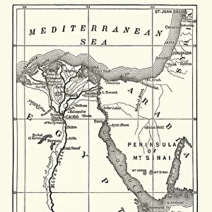
Africa map 1892
Frye Grammar School Geography - 1892
Unleash your creativity and transform your space into a visual masterpiece!
THEPALMER
Media ID 14756012
© This content is subject to copyright
27x27 inch Poster Print
Step back in time with our exquisite Africa Map 1892 print from THEPALMER's Fine Art Storehouse collection. This captivating poster, originally created for the Frye Grammar School Geography in 1892, showcases a fascinating glimpse into the historical geography of Africa during a significant era. Adorn your walls with this beautiful piece of educational art, transporting you back to an era of exploration and discovery. Add a touch of history and character to your space with this unique and intriguing poster print from Media Storehouse.
Poster prints are budget friendly enlarged prints in standard poster paper sizes. Printed on 150 gsm Matte Paper for a natural feel and supplied rolled in a tube. Great for framing and should last many years. To clean wipe with a microfiber, non-abrasive cloth or napkin. Our Archival Quality Photo Prints and Fine Art Paper Prints are printed on higher quality paper and the choice of which largely depends on your budget.
Poster prints are budget friendly enlarged prints in standard poster paper sizes (A0, A1, A2, A3 etc). Whilst poster paper is sometimes thinner and less durable than our other paper types, they are still ok for framing and should last many years. Our Archival Quality Photo Prints and Fine Art Paper Prints are printed on higher quality paper and the choice of which largely depends on your budget.
Estimated Product Size is 69.2cm x 69.2cm (27.2" x 27.2")
These are individually made so all sizes are approximate
Artwork printed orientated as per the preview above, with landscape (horizontal) or portrait (vertical) orientation to match the source image.
FEATURES IN THESE COLLECTIONS
> Fine Art Storehouse
> Map
> Historical Maps
> Maps and Charts
> Related Images
EDITORS COMMENTS
This print showcases a historical gem, the "Africa map 1892 (Frye Grammar School Geography - 1892)" captured by THEPALMER. Stepping back in time, this piece takes us on a visual journey to the late 19th century when cartography was an art form in itself. The intricate details and vibrant colors of this vintage map are truly mesmerizing. The map represents Africa as it was known over a century ago, offering a glimpse into the continent's rich history and diverse geography. Each contour line and meticulously labeled region tells its own story, inviting viewers to explore the vastness of Africa's landscapes and cultures. As we delve deeper into this artwork, we can't help but appreciate the craftsmanship that went into creating such an accurate representation of Africa during that era. It serves as a testament to human curiosity and our endless quest for knowledge about our world. This print is not just an aesthetic delight; it also holds educational value. It reminds us how far we have come in understanding our planet while honoring those who paved the way for modern cartography. Whether displayed in classrooms or personal spaces, this piece sparks conversations about exploration, history, and cultural diversity. THEPALMER has masterfully preserved this antique treasure through their lens, allowing us all to cherish and appreciate the beauty of maps as both works of art and invaluable sources of information about our past.
MADE IN THE USA
Safe Shipping with 30 Day Money Back Guarantee
FREE PERSONALISATION*
We are proud to offer a range of customisation features including Personalised Captions, Color Filters and Picture Zoom Tools
SECURE PAYMENTS
We happily accept a wide range of payment options so you can pay for the things you need in the way that is most convenient for you
* Options may vary by product and licensing agreement. Zoomed Pictures can be adjusted in the Basket.