Poster Print > Europe > Spain > Related Images
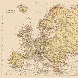
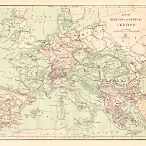
Poster Print : Map of Europe 1883


![]()
Poster Prints From Fine Art Storehouse
Map of Europe 1883
Warrens Common School Geography
Unleash your creativity and transform your space into a visual masterpiece!
THEPALMER
Media ID 13669363
© This content is subject to copyright
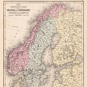
Austria Denmark Norway Paper Portugal Russia Sweden
18x24 inch Poster Print
Step back in time with our exquisite Map of Europe 1883 print from THEPALMER's Fine Art Storehouse collection. This captivating vintage map takes you on a journey through history, showcasing Europe's political landscape as it appeared over a century ago. Ideal for history enthusiasts, educators, or those who appreciate the aesthetic charm of antique maps, this print is a must-have addition to any home or office space. Immerse yourself in the intricacies of European geography as depicted in Warrens Common School's classic design. Bring a piece of the past into your present with our high-quality poster prints.
Poster prints are budget friendly enlarged prints in standard poster paper sizes. Printed on 150 gsm Matte Paper for a natural feel and supplied rolled in a tube. Great for framing and should last many years. To clean wipe with a microfiber, non-abrasive cloth or napkin. Our Archival Quality Photo Prints and Fine Art Paper Prints are printed on higher quality paper and the choice of which largely depends on your budget.
Poster prints are budget friendly enlarged prints in standard poster paper sizes (A0, A1, A2, A3 etc). Whilst poster paper is sometimes thinner and less durable than our other paper types, they are still ok for framing and should last many years. Our Archival Quality Photo Prints and Fine Art Paper Prints are printed on higher quality paper and the choice of which largely depends on your budget.
Estimated Product Size is 61.6cm x 46.3cm (24.3" x 18.2")
These are individually made so all sizes are approximate
Artwork printed orientated as per the preview above, with landscape (horizontal) orientation to match the source image.
FEATURES IN THESE COLLECTIONS
> Fine Art Storehouse
> The Magical World of Illustration
> Palmer Illustrated Collection
> Fine Art Storehouse
> Map
> Denmark Maps
> Fine Art Storehouse
> Map
> Historical Maps
> Fine Art Storehouse
> Map
> Italian Maps
> Europe
> Italy
> Related Images
> Europe
> Russia
> Related Images
> Europe
> Spain
> Related Images
EDITORS COMMENTS
This print titled "Map of Europe 1883 (Warrens Common School Geography)" takes us on a journey back in time, immersing us in the intricate details of an era long gone. The image showcases a horizontal map, meticulously crafted with delicate engravings and illustrations that bring to life the physical geography of Europe during the late 19th century. As our eyes wander across this antique cartography masterpiece, we are transported to a world where borders were different, nations had distinct identities, and history was yet to unfold. From Russia's vast expanse stretching eastward to France's elegant contours embracing its western neighbors; from Denmark's quaint presence nestled between Germany and Norway to Sweden's majestic prominence up north - every country is depicted with precision and artistry. The map also offers glimpses into other European nations like Austria, Italy, Portugal, Spain - each marked by their unique characteristics etched onto aged paper. Amidst these familiar names lies an unexpected inclusion: the United States. A reminder that even across vast oceans, connections were being forged during this transformative period. "The Map of Europe 1883" serves as both a historical artifact and a work of art. Its enchanting beauty invites us to explore not only the geographical landscape but also ponder upon how societies have evolved over time. This remarkable piece curated by THEPALMER captures our imagination while reminding us of the rich tapestry woven by centuries past.
MADE IN THE USA
Safe Shipping with 30 Day Money Back Guarantee
FREE PERSONALISATION*
We are proud to offer a range of customisation features including Personalised Captions, Color Filters and Picture Zoom Tools
SECURE PAYMENTS
We happily accept a wide range of payment options so you can pay for the things you need in the way that is most convenient for you
* Options may vary by product and licensing agreement. Zoomed Pictures can be adjusted in the Basket.