Pillow > Europe > United Kingdom > England > Sussex > Eartham
Pillow : Eartham tithe map, 1840


![]()
Home Decor From West Sussex County Council
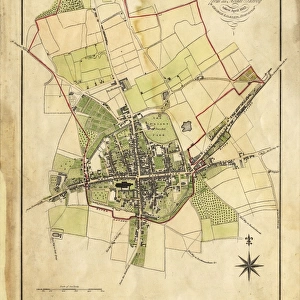
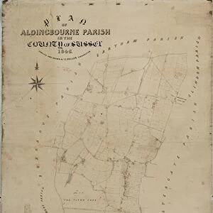
Eartham tithe map, 1840
Enlarged from the Inclosure Map made in 1813. Revised and corrected to the present time for the Commutation of the Tithes of the Parish of Eartham. By J. Butler, Chichester. 13.3 in. to 1m. 40 × 25
Tithe Award Map Collection
West Sussex Record Office Ref No: TD/W44
West Sussex County Council Record Office contains a fascinating history of the county of West Sussex, England
Media ID 10716291
© West Sussex County Council - All Rights Reserved
1840s 19th Century Historical Mapping South Of England
18"x18" (46x46cm) Pillow
18"x18" (46x46cm) Faux Suede Pillow with a plush soft feel. Your choice of image fills the front, with a stone colored faux suede back. Flat sewn concealed white zip.
Accessorise your space with decorative, soft pillows
Estimated Product Size is 45.7cm x 45.7cm (18" x 18")
These are individually made so all sizes are approximate
Artwork printed orientated as per the preview above, with landscape (horizontal) or portrait (vertical) orientation to match the source image.
FEATURES IN THESE COLLECTIONS
> Europe
> United Kingdom
> England
> Chichester
> Europe
> United Kingdom
> England
> Maps
> Europe
> United Kingdom
> England
> Sussex
> Chichester
> Europe
> United Kingdom
> England
> Sussex
> Eartham
> Europe
> United Kingdom
> England
> Sussex
> Related Images
> Europe
> United Kingdom
> England
> West Sussex
> Chichester
> Europe
> United Kingdom
> England
> West Sussex
> Related Images
> Maps and Charts
> Early Maps
> Maps and Charts
> Related Images
> West Sussex County Council
> West Sussex Record Office
> Tithe Award Maps, 1808-1859
EDITORS COMMENTS
This print showcases the Eartham tithe map from 1840, which was enlarged from the Inclosure Map created in 1813. The meticulous revisions and corrections made by J. Butler of Chichester bring this historical piece up to date for the Commutation of the Tithes of the Parish of Eartham. Measuring at an impressive scale of 13.3 inches to 1 meter, this map offers a detailed glimpse into the past. Part of the esteemed Tithe Award Map Collection held at West Sussex Record Office, this artifact provides valuable insights into land ownership and usage during the early decades of the 19th century in southern England. Its historical significance cannot be overstated as it sheds light on how communities were structured and cultivated during that era. Preserved with utmost care, this print serves as a testament to West Sussex County Council's commitment to safeguarding our rich heritage for future generations. It is important to note that any commercial use or affiliation is not associated with this image; rather, its purpose lies in education and appreciation for our shared history. Whether you are a historian seeking deeper understanding or simply intrigued by cartography, this remarkable piece invites you to explore Eartham's landscape through time and immerse yourself in its fascinating narrative.
MADE IN THE USA
Safe Shipping with 30 Day Money Back Guarantee
FREE PERSONALISATION*
We are proud to offer a range of customisation features including Personalised Captions, Color Filters and Picture Zoom Tools
SECURE PAYMENTS
We happily accept a wide range of payment options so you can pay for the things you need in the way that is most convenient for you
* Options may vary by product and licensing agreement. Zoomed Pictures can be adjusted in the Basket.