Fraud Blocker Skip to main content

Pillow > Europe > United Kingdom > England > London > Sights > British Museum

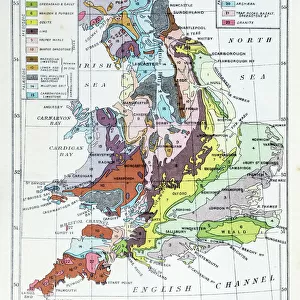
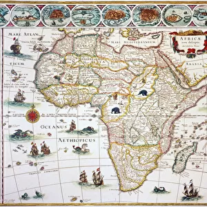
Pillow : Geological map of Britain and Ireland

Geological map of Britain and Ireland


We accept all major credit cards


Canvas Prints
Fine Art Prints
Metal Prints
Home Decor


Mary Evans Prints Online

Home Decor from Mary Evans Picture Library

Geological map of Britain and Ireland

Fig 9 from Britain Before Man (1978), a Geological Museum publication

Mary Evans Picture Library makes available wonderful images created for people to enjoy over the centuries

Media ID 8613371

© Mary Evans Picture Library 2015 - https://copyrighthub.org/s0/hub1/creation/maryevans/MaryEvansPictureID/10706165

Before Geological Geology Great Britain United Kingdom


18"x18" (46x46cm) Pillow

18"x18" (46x46cm) Faux Suede Pillow with a plush soft feel. Your choice of image fills the front, with a stone colored faux suede back. Flat sewn concealed white zip.

Accessorise your space with decorative, soft pillows

Estimated Product Size is 45.7cm x 45.7cm (18" x 18")

These are individually made so all sizes are approximate

Artwork printed orientated as per the preview above, with landscape (horizontal) or portrait (vertical) orientation to match the source image.


FEATURES IN THESE COLLECTIONS

> Europe > Related Images

> Europe > Republic of Ireland > Maps

> Europe > United Kingdom > England > London > Sights > British Museum

> Europe > United Kingdom > Related Images

> Maps and Charts > Geological Map

> Maps and Charts > Ireland

> Maps and Charts > Related Images

> Popular Themes > Geological


MADE IN THE USA
Safe Shipping with 30 Day Money Back Guarantee

FREE PERSONALISATION*
We are proud to offer a range of customisation features including Personalised Captions, Color Filters and Picture Zoom Tools

SECURE PAYMENTS
We happily accept a wide range of payment options so you can pay for the things you need in the way that is most convenient for you

* Options may vary by product and licensing agreement. Zoomed Pictures can be adjusted in the Cart.


public
Made in USA
loyalty
Includes Free Shipping
price_check
Bulk discounts at checkout
thumb_up
Professional quality finish
diamond
Made with high-grade materials
inventory_2
Carefully packed to aid safe arrival


Related Images


William Smith Geological Map
Antique colored illustrations: Geological map of England and Wales
Battle of Waterloo map J020089
British Isles Counties, Districts and Unitary Authorities Map
Geological map of the British Islands
Slaters Bridge, Little Langdale, Lake District, Cumbria, England, United Kingdom, Europe
Butlers Wharf c. 1910 BB87_09668
Naval Battle 1782
Naval Battle 1782
MAP OF AFRICA, 1630. Willem Blaeus ornamental map of Africa Newly Described
William Smiths Geological Map
The Third Man Poster

+

Shipping

+

Choices

+

Reviews

+

Guaranteed


Related Collections


Geological Map
Geological Map
Browse 411 Prints
Geological
Geological
Browse 6,606 Prints
Europe Related Images
Browse 45,635 Prints
United Kingdom Related Images
Browse 44,335 Prints
Maps
Maps
Browse 1,158 Prints
Maps and Charts Related Images
Browse 46,916 Prints
British Museum
British Museum
Browse 27,137 Prints
Ireland
Ireland
Browse 1,158 Prints