Pillow > Arts > Photorealistic artworks > Detailed art pieces > Masterful detailing in art
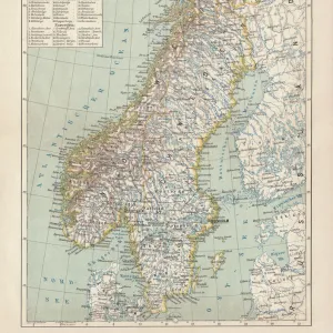
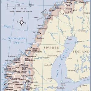
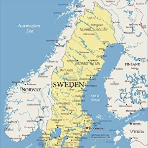
Pillow : Old Map of Sweden and Norway 1852 by Henry George Collins


![]()
Home Decor From MapSeeker
Old Map of Sweden and Norway 1852 by Henry George Collins
This is a finely detailed map of Sweden and Norway remastered from a rare Atlas of the World published in 1852 by Henry George Collins. Although these Henry Collins produced maps of the highest quality in his time unfortunately not the same could be said in terms of his business success. His maps were later obtained by the famous Stanford Map Company and used in their publications
Welcome to the Mapseeker Image library and enter an historic gateway to one of the largest on-line collections of Historic Maps, Nostalgic Views, Vista's and Panorama's from a World gone by.
Media ID 20347418
© Mapseeker Publishing Ltd
Collins Collins Atlas Collins Atlas Map Collins Map
18"x18" (46x46cm) Pillow
18"x18" (46x46cm) Faux Suede Pillow with a plush soft feel. Your choice of image fills the front, with a stone colored faux suede back. Flat sewn concealed white zip.
Accessorise your space with decorative, soft pillows
Estimated Product Size is 45.7cm x 45.7cm (18" x 18")
These are individually made so all sizes are approximate
Artwork printed orientated as per the preview above, with landscape (horizontal) or portrait (vertical) orientation to match the source image.
FEATURES IN THESE COLLECTIONS
> MapSeeker
> Maps of Europe
> Maps of Scandinavia PORTFOLIO
> Arts
> Photorealistic artworks
> Detailed art pieces
> Masterful detailing in art
> Europe
> Norway
> Related Images
> Europe
> Sweden
> Related Images
> Maps and Charts
> World
EDITORS COMMENTS
This beautifully preserved print showcases an exquisite piece of cartographic history - the "Old Map of Sweden and Norway 1852" by Henry George Collins. Remastered from a rare Atlas of the World published in 1852, this map offers a fascinating glimpse into the geographical landscape of these Nordic countries during that era. Henry George Collins was renowned for his exceptional craftsmanship, evident in the intricate details and accuracy depicted on this map. However, despite his undeniable talent, he faced challenges in achieving commercial success with his maps. Fortunately, his remarkable works were later acquired by the esteemed Stanford Map Company, which recognized their value and incorporated them into their own publications. The Old Map of Sweden and Norway takes us back to a time when these nations were united under one crown. It allows us to explore historic cities like Stockholm and Oslo while tracing ancient trade routes through dense forests and along picturesque coastlines. The delicate lines demarcating borders reveal political divisions that have evolved over time. As we admire this old Swedish-Norwegian map, we are reminded not only of its aesthetic appeal but also its historical significance. It serves as a testament to Henry George Collins' dedication to producing top-quality maps that continue to captivate enthusiasts today.
MADE IN THE USA
Safe Shipping with 30 Day Money Back Guarantee
FREE PERSONALISATION*
We are proud to offer a range of customisation features including Personalised Captions, Color Filters and Picture Zoom Tools
SECURE PAYMENTS
We happily accept a wide range of payment options so you can pay for the things you need in the way that is most convenient for you
* Options may vary by product and licensing agreement. Zoomed Pictures can be adjusted in the Basket.