Pillow > Europe > France > Maps
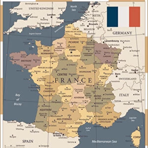
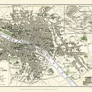
Pillow : Map of France Showing the Territories held respectively by the French and German Armies January 1871


![]()
Home Decor From MapSeeker
Map of France Showing the Territories held respectively by the French and German Armies January 1871
BAT01001
Welcome to the Mapseeker Image library and enter an historic gateway to one of the largest on-line collections of Historic Maps, Nostalgic Views, Vista's and Panorama's from a World gone by.
Media ID 20348112
18"x18" (46x46cm) Pillow
18"x18" (46x46cm) Faux Suede Pillow with a plush soft feel. Your choice of image fills the front, with a stone colored faux suede back. Flat sewn concealed white zip.
Accessorise your space with decorative, soft pillows
Estimated Product Size is 45.7cm x 45.7cm (18" x 18")
These are individually made so all sizes are approximate
Artwork printed orientated as per the preview above, with landscape (horizontal) or portrait (vertical) orientation to match the source image.
FEATURES IN THESE COLLECTIONS
> MapSeeker
> British History Related and Military
> 16th to 19th Century PORTFOLIO
> MapSeeker
> Maps of Europe
> Maps of France PORTFOLIO
EDITORS COMMENTS
This print showcases a historical treasure, the "Map of France Showing the Territories held respectively by the French and German Armies January 1871". A visual testament to a tumultuous period in European history, this war map provides invaluable insights into the territorial divisions between France and Germany during that time. The intricate details of this map are truly remarkable. Every line, contour, and symbol tells a story of conflict and power struggles. It vividly illustrates how both French and German armies occupied different regions within France in January 1871. The contrasting colors on the map highlight these distinct territories, offering viewers an immediate understanding of the complex dynamics at play during this era. As we gaze upon this historic artifact, our minds wander back to that fateful period when tensions ran high across Europe. This map serves as a reminder of the devastating consequences brought about by war but also highlights resilience and determination exhibited by nations seeking their rightful place. Preserved with utmost care, this print from MapSeeker allows us to delve deep into history's pages. Whether you are an avid historian or simply intrigued by maps' ability to narrate stories visually, this piece is sure to captivate your imagination. Let it transport you back in time as you explore each detail etched onto its surface – an enduring testimony to human conflicts that shaped nations forever.
MADE IN THE USA
Safe Shipping with 30 Day Money Back Guarantee
FREE PERSONALISATION*
We are proud to offer a range of customisation features including Personalised Captions, Color Filters and Picture Zoom Tools
SECURE PAYMENTS
We happily accept a wide range of payment options so you can pay for the things you need in the way that is most convenient for you
* Options may vary by product and licensing agreement. Zoomed Pictures can be adjusted in the Basket.