Pillow > North America > United States of America > New York > Related Images
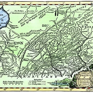
Pillow : Pennsylvania state USA map 1881


![]()
Home Decor From Fine Art Storehouse
Pennsylvania state USA map 1881
Harpers School Geography, New York, Harpers and Brothers, 1881
Unleash your creativity and transform your space into a visual masterpiece!
THEPALMER
Media ID 14756084
© This content is subject to copyright
Pennsylvania Philadelphia Pittsburgh Appalachian Mountains Harrisburg
18"x18" (46x46cm) Pillow
18"x18" (46x46cm) Faux Suede Pillow with a plush soft feel. Your choice of image fills the front, with a stone colored faux suede back. Flat sewn concealed white zip.
Accessorise your space with decorative, soft pillows
Estimated Product Size is 45.7cm x 45.7cm (18" x 18")
These are individually made so all sizes are approximate
Artwork printed orientated as per the preview above, with landscape (horizontal) or portrait (vertical) orientation to match the source image.
FEATURES IN THESE COLLECTIONS
> Fine Art Storehouse
> Map
> Historical Maps
> Fine Art Storehouse
> Map
> USA Maps
> North America
> United States of America
> New York
> Related Images
EDITORS COMMENTS
This print showcases a vintage map of Pennsylvania, USA, dating back to the year 1881. Taken from Harpers School Geography in New York and published by Harpers and Brothers, this historical piece offers a glimpse into the state's past. The intricate details on the map highlight various significant landmarks and cities such as Harrisburg, Philadelphia, Pittsburgh, and the majestic Appalachian Mountains. The artist behind this remarkable creation is known as THEPALMER. With their skilled eye for detail and appreciation for history, they have expertly captured this piece of cartographic artistry. The fine craftsmanship evident in every line and stroke brings forth an air of nostalgia that transports viewers back to a time long gone. As you gaze upon this exquisite print, you can't help but be drawn into its rich narrative. It serves as a reminder of Pennsylvania's vibrant heritage and its role in shaping American history. Whether you're a native Pennsylvanian or simply fascinated by historical maps, this artwork will undoubtedly spark curiosity about the state's past. Displaying "Pennsylvania State USA Map 1881" proudly on your wall not only adds an elegant touch to your decor but also serves as a conversation starter among friends and family. Let it serve as a testament to our collective fascination with exploration, geography, and the timeless beauty found within antique cartography.
MADE IN THE USA
Safe Shipping with 30 Day Money Back Guarantee
FREE PERSONALISATION*
We are proud to offer a range of customisation features including Personalised Captions, Color Filters and Picture Zoom Tools
SECURE PAYMENTS
We happily accept a wide range of payment options so you can pay for the things you need in the way that is most convenient for you
* Options may vary by product and licensing agreement. Zoomed Pictures can be adjusted in the Basket.