Pillow > Arts > Artists > O > Oceanic Oceanic
Pillow : World map from 1520


![]()
Home Decor from Fine Art Storehouse
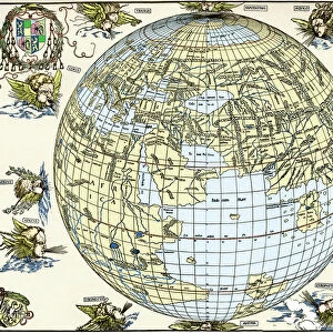
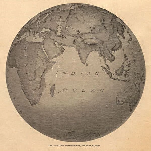
World map from 1520
Western hemisphere of the Johannes SchAoner globe from 1520. expedition
Unleash your creativity and transform your space into a visual masterpiece!
Nastasic
Media ID 15193178
© Nikola Nastasic
1940 1980 Retro Styled Imagery Atlantic Ocean Australia Burnt Direction Dirty Document Exploration Frame Globe Man Made Object Grunge Image Created 1830 1839 Migrating Newspaper Ornate Paper Parchment Picture Frame Rustic Sphere Stained Textured Textured Effect The Americas Torn Unhygienic Wallpaper Pattern World Map 1520 Dissemination Muller Obsolete Painted Image Retro Styled
18"x18" (46x46cm) Pillow
18"x18" (46x46cm) Faux Suede Pillow with a plush soft feel. Your choice of image fills the front, with a stone colored faux suede back. Flat sewn concealed white zip.
Accessorise your space with decorative, soft pillows
Estimated Product Size is 45.7cm x 45.7cm (18" x 18")
These are individually made so all sizes are approximate
Artwork printed orientated as per the preview above, with landscape (horizontal) or portrait (vertical) orientation to match the source image.
FEATURES IN THESE COLLECTIONS
> Fine Art Storehouse
> Map
> Map Illustrations
> Africa
> Related Images
> Animals
> Mammals
> Muridae
> Western Mouse
> Arts
> Artists
> O
> Oceanic Oceanic
> Asia
> Related Images
> Europe
> Related Images
> Maps and Charts
> Early Maps
> Maps and Charts
> Related Images
EDITORS COMMENTS
This print takes us back in time to the year 1520, where we find ourselves exploring the Western hemisphere of Johannes Schöner's globe. The image, created between 1830 and 1839, beautifully captures the essence of this historical cartographic masterpiece. The retro-styled imagery adds a touch of nostalgia as we observe the unhygienic and stained parchment surface. The rustic frame surrounding the picture gives it an ornate feel, reminiscent of a bygone era. Its textured effect further enhances its vintage charm. As we delve into this ancient world map, our eyes are drawn to Asia, Europe, Africa, Australia, and the Americas—all meticulously depicted with intricate details. The vast Atlantic Ocean stretches across the scene like a sea of possibilities waiting to be explored. This artwork serves as a reminder of humanity's thirst for knowledge and exploration throughout history. It symbolizes our fascination with understanding our place in this vast sphere called Earth. Despite its aged appearance—dirty, torn, and even burnt in some areas—the map still holds immense value as a document that played a crucial role in disseminating geographical information during its time. Nastasic's skillful capture brings forth not only an appreciation for art but also sparks curiosity about our collective past. This piece invites us to reflect on how far we have come while acknowledging those who paved the way for future generations' discoveries.
MADE IN THE USA
Safe Shipping with 30 Day Money Back Guarantee
FREE PERSONALISATION*
We are proud to offer a range of customisation features including Personalised Captions, Color Filters and Picture Zoom Tools
SECURE PAYMENTS
We happily accept a wide range of payment options so you can pay for the things you need in the way that is most convenient for you
* Options may vary by product and licensing agreement. Zoomed Pictures can be adjusted in the Cart.