Pillow > Asia > Related Images
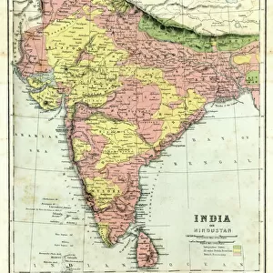
Pillow : Map of India, 1865 (colour litho)
")
")

Please select a smaller print size for this image
![]()
Home Decor From Fine Art Finder
Map of India, 1865 (colour litho)
XCF275022 Map of India, 1865 (colour litho) by English School, (19th century); Private Collection; English, out of copyright
Media ID 12790603
© www.bridgemanimages.com
British Empire British India British Raj Geographical Mapping Political Map
18"x18" (46x46cm) Pillow
18"x18" (46x46cm) Faux Suede Pillow with a plush soft feel. Your choice of image fills the front, with a stone colored faux suede back. Flat sewn concealed white zip.
Accessorise your space with decorative, soft pillows
Estimated Product Size is 45.7cm x 45.7cm (18" x 18")
These are individually made so all sizes are approximate
Artwork printed orientated as per the preview above, with landscape (horizontal) or portrait (vertical) orientation to match the source image.
EDITORS COMMENTS
This print showcases a remarkable piece of history - the "Map of India, 1865". Created by an anonymous English School artist in the 19th century, this colour lithograph offers a vivid depiction of British India during the colonial era. The map is housed in a private collection and has been made available to the public through Fine Art Finder. The intricate details and vibrant colors of this map invite viewers to explore the political divisions and geographical features that shaped India at that time. It serves as a valuable resource for cartography enthusiasts, historians, and anyone interested in understanding the dynamics of British rule in Asia. From its northernmost borders with Afghanistan to its southern tip near Sri Lanka, every inch of Indian territory is meticulously delineated on this map. The British Raj's influence can be seen throughout, as it controlled vast regions under its empire. As we gaze upon this image, we are transported back to an era when maps were not just navigational tools but also symbols of power and control. This particular print allows us to appreciate both the artistry involved in creating such detailed maps and their significance within historical contexts. Whether you are fascinated by cartography or simply intrigued by India's past, this print offers a glimpse into an important chapter in world history – one where empires clashed and cultures intertwined on the subcontinent.
MADE IN THE USA
Safe Shipping with 30 Day Money Back Guarantee
FREE PERSONALISATION*
We are proud to offer a range of customisation features including Personalised Captions, Color Filters and Picture Zoom Tools
SECURE PAYMENTS
We happily accept a wide range of payment options so you can pay for the things you need in the way that is most convenient for you
* Options may vary by product and licensing agreement. Zoomed Pictures can be adjusted in the Basket.