Pillow > Maps and Charts > Related Images
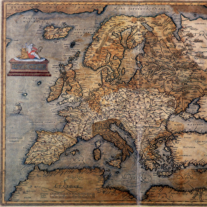
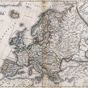
Pillow : Map of Europe in 1743


![]()
Home Decor From Fine Art Finder
Map of Europe in 1743
GIA4784924 Map of Europe in 1743. by Unknown artist, (18th century); Private Collection; (add.info.: Map of Europe in 1743.); eGiancarlo Costa; out of copyright
Media ID 23714792
© Giancarlo Costa / Bridgeman Images
18"x18" (46x46cm) Pillow
18"x18" (46x46cm) Faux Suede Pillow with a plush soft feel. Your choice of image fills the front, with a stone colored faux suede back. Flat sewn concealed white zip.
Accessorise your space with decorative, soft pillows
Estimated Product Size is 45.7cm x 45.7cm (18" x 18")
These are individually made so all sizes are approximate
Artwork printed orientated as per the preview above, with landscape (horizontal) or portrait (vertical) orientation to match the source image.
FEATURES IN THESE COLLECTIONS
> Fine Art Finder
> Artists
> Unknown Artist
> Arts
> Artists
> Related Images
> Maps and Charts
> Related Images
EDITORS COMMENTS
This print showcases a remarkable piece of history - the Map of Europe in 1743. Created by an unknown artist during the 18th century, this engraving offers a fascinating glimpse into the geographical landscape of Europe during that era. The intricate details and precise craftsmanship of this map are truly awe-inspiring. Every country, city, and river is meticulously depicted, allowing viewers to immerse themselves in the political and cultural tapestry of Europe over two centuries ago. From the vast expanses of Russia to the bustling cities of France and Germany, this map highlights both well-known landmarks and lesser-known regions with equal importance. As we gaze upon this historical artifact, it transports us back to a time when borders were different, empires rose and fell, and new discoveries shaped our understanding of the world. It serves as a reminder that history is not just confined within textbooks but can be visualized through art. Giancarlo Costa's expertly captured photograph brings out every minute detail with precision while maintaining its vintage charm. The sepia tones evoke a sense of nostalgia for times long gone by. Whether you're an avid historian or simply appreciate fine art, this print is sure to spark curiosity about Europe's past while adding an elegant touch to any space it graces.
MADE IN THE USA
Safe Shipping with 30 Day Money Back Guarantee
FREE PERSONALISATION*
We are proud to offer a range of customisation features including Personalised Captions, Color Filters and Picture Zoom Tools
SECURE PAYMENTS
We happily accept a wide range of payment options so you can pay for the things you need in the way that is most convenient for you
* Options may vary by product and licensing agreement. Zoomed Pictures can be adjusted in the Basket.