Pillow > Arts > Artists > B > Joan Blaeu
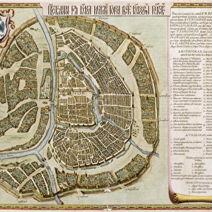
Pillow : Map depicting the East Coast of North America, 1647 (colour litho) (see 93602 and 216517)
 (see 93602 and 216517)")
 (see 93602 and 216517)")

![]()
Home Decor From Fine Art Finder
Map depicting the East Coast of North America, 1647 (colour litho) (see 93602 and 216517)
CHT216518 Map depicting the East Coast of North America, 1647 (colour litho) (see 93602 and 216517) by Blaeu, Joan (1596-1673); Private Collection; (add.info.: map shows New Amsterdam, the island of Manhattan; detail from the Atlas Blaeu; ); eArchives Charmet; Dutch, out of copyright
Media ID 23193288
© Archives Charmet / Bridgeman Images
18"x18" (46x46cm) Pillow
18"x18" (46x46cm) Faux Suede Pillow with a plush soft feel. Your choice of image fills the front, with a stone colored faux suede back. Flat sewn concealed white zip.
Accessorise your space with decorative, soft pillows
Estimated Product Size is 45.7cm x 45.7cm (18" x 18")
These are individually made so all sizes are approximate
Artwork printed orientated as per the preview above, with landscape (horizontal) or portrait (vertical) orientation to match the source image.
FEATURES IN THESE COLLECTIONS
> Fine Art Finder
> Artists
> Joan Blaeu
> Fine Art Finder
> Artists
> Photographer English
> Fine Art Finder
> Maps (celestial & Terrestrial)
> Arts
> Artists
> B
> Joan Blaeu
> Maps and Charts
> Related Images
> Popular Themes
> North Island
> Transportation
> Ships and Boats
EDITORS COMMENTS
This print showcases a remarkable map depicting the East Coast of North America in 1647. Created by the renowned cartographer Joan Blaeu, this color lithograph offers a fascinating glimpse into the historical landscape of the time. The map features various notable locations, including New Amsterdam and the iconic island of Manhattan. As we delve deeper into this intricate artwork, we are transported back to an era where exploration and discovery were at their peak. The map reveals a rich tapestry of details, from boats gracefully sailing along the coast to indigenous canoes gliding through pristine waters. A Dutch ship proudly stands out amidst these scenes, symbolizing the European presence in this new world. One intriguing aspect that catches our attention is an unexpected twist: part of the map is depicted upside down. This unconventional choice adds an element of surprise and invites us to question traditional perspectives on geography. The sheer beauty and precision of Blaeu's craftsmanship are evident in every stroke and contour. This particular print is derived from his esteemed Atlas Blaeu collection, which remains highly regarded among historians and art enthusiasts alike. As we gaze upon this extraordinary piece, it serves as a reminder not only of our collective past but also as an invitation to explore further into history's mysteries. It captures both the spirit of adventure that defined this era and pays homage to those who paved the way for future generations' understanding of our world's vast landscapes.
MADE IN THE USA
Safe Shipping with 30 Day Money Back Guarantee
FREE PERSONALISATION*
We are proud to offer a range of customisation features including Personalised Captions, Color Filters and Picture Zoom Tools
SECURE PAYMENTS
We happily accept a wide range of payment options so you can pay for the things you need in the way that is most convenient for you
* Options may vary by product and licensing agreement. Zoomed Pictures can be adjusted in the Basket.