Pillow > Arts > Artists > A > Battista Agnese
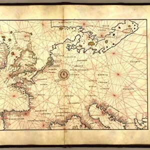
Pillow : A double-page map of the Atlantic Ocean, showing the east coast of North


![]()
Home Decor From Fine Art Finder
A double-page map of the Atlantic Ocean, showing the east coast of North
985950 A double-page map of the Atlantic Ocean, showing the east coast of North and South America, 1544 (illuminated manuscript on vellum) by Agnese, Battista (1514-64); 21.8x35 (approx) cm; Private Collection; (add.info.: A double-page map of the Atlantic Ocean, showing the east coast of North and South America. Map 2 from a Portolan Atlas. Battista Agnese (1514-1564). Illuminated manuscript on vellum. Made in Venice circa 1544. 21.8 x 35cm (approx).); Photo eChristies Images; Italian, out of copyright
Media ID 22491672
© Christie's Images / Bridgeman Images
1544 Atlantic Atlantic Ocean Atlas Chart Double Page East Geographic Illuminated Manuscript Italian Art Italian Artist Navigation Navigational Equipment On Vellum Page Portolan Agnese Agnese Battista Natural Space
18"x18" (46x46cm) Pillow
18"x18" (46x46cm) Faux Suede Pillow with a plush soft feel. Your choice of image fills the front, with a stone colored faux suede back. Flat sewn concealed white zip.
Accessorise your space with decorative, soft pillows
Estimated Product Size is 45.7cm x 45.7cm (18" x 18")
These are individually made so all sizes are approximate
Artwork printed orientated as per the preview above, with landscape (horizontal) or portrait (vertical) orientation to match the source image.
FEATURES IN THESE COLLECTIONS
> Fine Art Finder
> Artists
> Battista Agnese
> Fine Art Finder
> Artists
> Nikolaus Friedrich Eisenberger
> Fine Art Finder
> Temp Classification
> Arts
> Artists
> A
> Battista Agnese
> Arts
> Artists
> O
> Oceanic Oceanic
> Europe
> Italy
> Veneto
> Venice
> Maps and Charts
> Italy
> Maps and Charts
> Related Images
EDITORS COMMENTS
This print showcases a double-page map of the Atlantic Ocean, specifically highlighting the east coast of North and South America. Created by the talented Italian artist Battista Agnese in 1544, this illuminated manuscript on vellum is a true masterpiece. Measuring approximately 21.8x35 cm, it is part of a larger Portolan Atlas. The intricate details and precision of this map demonstrate Agnese's expertise in cartography. Navigational equipment such as charts and manuscripts were meticulously used to accurately depict the coastline, shorelines, and geographic features of both continents. The vibrant colors and delicate illumination further enhance its beauty. As we gaze upon this artwork, we are transported back in time to an era when maritime exploration was at its peak. This map served as an invaluable tool for sailors navigating across the vast Atlantic Ocean. It not only provided essential information about water currents but also acted as a guide for safe passage along treacherous coastlines. The significance of this piece lies not only in its artistic value but also in its historical importance. It represents a crucial period when European explorers were discovering new lands and expanding their knowledge of the world. Now preserved within a private collection, this rare gem allows us to appreciate Agnese's talent as well as gain insight into our planet's past exploration endeavors.
MADE IN THE USA
Safe Shipping with 30 Day Money Back Guarantee
FREE PERSONALISATION*
We are proud to offer a range of customisation features including Personalised Captions, Color Filters and Picture Zoom Tools
SECURE PAYMENTS
We happily accept a wide range of payment options so you can pay for the things you need in the way that is most convenient for you
* Options may vary by product and licensing agreement. Zoomed Pictures can be adjusted in the Basket.