Pillow > Arts > Artists > H > Hendrik Hondius
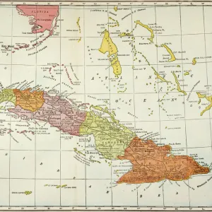
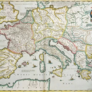
Pillow : Cuba Insula; Hispaniola Insula, engraved by Hendrik Hondius, 1633 (engraving)
")
")

![]()
Home Decor from Fine Art Finder
Cuba Insula; Hispaniola Insula, engraved by Hendrik Hondius, 1633 (engraving)
5648408 Cuba Insula; Hispaniola Insula, engraved by Hendrik Hondius, 1633 (engraving) by Mercator, Gerard (1512-94) (after); 48x57 cm; Boston Public Library, Boston, Massachusetts, USA; Flemish, out of copyright
Media ID 23273790
© Bridgeman Images
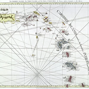
Antilles Caribbean Islands Mapping Tropical Virgin Islands West Indian West Indies Vintage Map
18"x18" (46x46cm) Pillow
18"x18" (46x46cm) Faux Suede Pillow with a plush soft feel. Your choice of image fills the front, with a stone colored faux suede back. Flat sewn concealed white zip.
Accessorise your space with decorative, soft pillows
Estimated Product Size is 45.7cm x 45.7cm (18" x 18")
These are individually made so all sizes are approximate
Artwork printed orientated as per the preview above, with landscape (horizontal) or portrait (vertical) orientation to match the source image.
FEATURES IN THESE COLLECTIONS
> Fine Art Finder
> Artists
> Gerard (after) Mercator
> Arts
> Artists
> H
> Hendrik Hondius
> Maps and Charts
> Related Images
> North America
> Cuba
> Maps
> North America
> Cuba
> Related Images
> North America
> United States of America
> Maps
> North America
> United States of America
> Massachusetts
> Boston
> North America
> United States of America
> Massachusetts
> Related Images
> North America
> US Virgin Islands
> Maps
EDITORS COMMENTS
This print showcases a vintage map titled "Cuba Insula; Hispaniola Insula" engraved by Hendrik Hondius in 1633. The intricate details and exquisite craftsmanship of this engraving transport us back to the golden age of cartography. Measuring 48x57 cm, this historical piece is housed at the Boston Public Library in Massachusetts, USA. It was created by Gerard Mercator, a renowned Flemish cartographer from the 16th century. With its vibrant colors and precise lines, it offers a glimpse into the rich history and geography of the Caribbean islands. The map encompasses not only Cuba and Hispaniola but also various other islands such as the Virgin Islands and Antilles. Its tropical allure transports viewers to these idyllic destinations, evoking visions of palm-fringed beaches and crystal-clear waters. As we admire this vintage map, we are reminded of how maps have played an integral role in our understanding of the world throughout history. They have served as navigational tools for explorers while also capturing cultural nuances and geographical features unique to each region. This print from Bridgeman Images serves as a testament to both artistry and functionality. It allows us to appreciate not only its aesthetic beauty but also its significance in documenting our ever-evolving world.
MADE IN THE USA
Safe Shipping with 30 Day Money Back Guarantee
FREE PERSONALISATION*
We are proud to offer a range of customisation features including Personalised Captions, Color Filters and Picture Zoom Tools
SECURE PAYMENTS
We happily accept a wide range of payment options so you can pay for the things you need in the way that is most convenient for you
* Options may vary by product and licensing agreement. Zoomed Pictures can be adjusted in the Cart.