Pillow > Aerial Photography > France
Pillow : Map of the Battle of Trafalgar, published by William Blackwood and Sons


![]()
Home Decor From Fine Art Finder
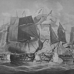
Map of the Battle of Trafalgar, published by William Blackwood and Sons
746913 Map of the Battle of Trafalgar, published by William Blackwood and Sons, Edinburgh & London, 1848 (hand-coloured engraving) by Johnston, Alexander Keith (1804-71); Private Collection; (add.info.: Battle of Trafalgar (21 October 1805)); The Stapleton Collection; Scottish, out of copyright
Media ID 22424816
© The Stapleton Collection / Bridgeman Images
Aerial View Mapping Positions Sea Battle War Of The Third Coalition
18"x18" (46x46cm) Pillow
18"x18" (46x46cm) Faux Suede Pillow with a plush soft feel. Your choice of image fills the front, with a stone colored faux suede back. Flat sewn concealed white zip.
Accessorise your space with decorative, soft pillows
Estimated Product Size is 45.7cm x 45.7cm (18" x 18")
These are individually made so all sizes are approximate
Artwork printed orientated as per the preview above, with landscape (horizontal) or portrait (vertical) orientation to match the source image.
FEATURES IN THESE COLLECTIONS
> Fine Art Finder
> Artists
> Alexander Keith Johnston
> Fine Art Finder
> Maps (celestial & Terrestrial)
> Aerial Photography
> Related Images
> Aerial Photography
> Scotland
> Arts
> Artists
> A
> William Alexander
> Arts
> Artists
> K
> William Keith
> Europe
> Spain
> Aerial Views
EDITORS COMMENTS
This print showcases a remarkable piece of history - the Map of the Battle of Trafalgar, published by William Blackwood and Sons in 1848. Crafted by Alexander Keith Johnston, this hand-coloured engraving offers an aerial view of the infamous naval battle that took place on 21 October 1805. The map provides intricate details about the positions and movements of ships involved in this significant event during the Napoleonic Wars. It vividly captures both Spanish and French vessels engaged in combat with the Royal Navy, depicting a fierce clash between opposing forces. As we delve into this historical masterpiece, we are transported back to a time when naval supremacy was fiercely contested. The meticulously drawn ships convey their grandeur and power as they navigate through treacherous waters. This map not only serves as a visual representation but also acts as an invaluable resource for understanding the strategies employed during this decisive battle. Beyond its cartographic significance, this print is a testament to human ingenuity and artistic skill. The hand-colouring adds depth and vibrancy to each element depicted, breathing life into an otherwise static image. Incorporating elements from various disciplines such as cartography, maritime history, and artistry, this print exemplifies how fine art can serve as an educational tool while simultaneously evoking emotions associated with past events.
MADE IN THE USA
Safe Shipping with 30 Day Money Back Guarantee
FREE PERSONALISATION*
We are proud to offer a range of customisation features including Personalised Captions, Color Filters and Picture Zoom Tools
SECURE PAYMENTS
We happily accept a wide range of payment options so you can pay for the things you need in the way that is most convenient for you
* Options may vary by product and licensing agreement. Zoomed Pictures can be adjusted in the Basket.