Pillow > Africa > Guinea > Maps
Pillow : Map of Australasia (1882 engraving)
")
")

![]()
Home Decor From Australian Views
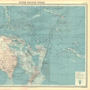
Map of Australasia (1882 engraving)
Old map of Australasia from "Royal Geographical Readers no. 5" of Asia, Africa, America and Oceania, publ. T Nelson & Sons, London in 1883
Unveiling the Splendour of Australia through Exquisite Artwork
whitemay
155157966
Media ID 31999245
© Linda Steward
19th Century Style Antique Asia British Empire Cartography Colonial Style Coral Sea Drawing Engraved Image Exploration History Illustration And Painting Image Created 19th Century Indonesia Java Monochrome New South Wales New Zealand Northern Territory Obsolete Old Fashioned Pacific Ocean Papua New Guinea Past Physical Geography Polynesia Queensland Sepia Toned Sketch South Australia Tasmania Traditional Culture Travel Western Australia Antarctic Sea Celebes Sea Ephemera Image Created 1880 1889 Island Of Borneo North Australia Social History Solomon Islands Victoria State
18"x18" (46x46cm) Pillow
18"x18" (46x46cm) Faux Suede Pillow with a plush soft feel. Your choice of image fills the front, with a stone colored faux suede back. Flat sewn concealed white zip.
Accessorise your space with decorative, soft pillows
Estimated Product Size is 45.7cm x 45.7cm (18" x 18")
These are individually made so all sizes are approximate
Artwork printed orientated as per the preview above, with landscape (horizontal) or portrait (vertical) orientation to match the source image.
FEATURES IN THESE COLLECTIONS
> Africa
> Guinea
> Related Images
> Africa
> South Africa
> Maps
> Africa
> South Africa
> Related Images
> Animals
> Mammals
> Muridae
> Western Mouse
> Arts
> Artists
> O
> Oceanic Oceanic
> Arts
> Minimalist artwork
> Monochrome artwork
> Fine art
> Arts
> Minimalist artwork
> Monochrome artwork
> Monochrome paintings
> Asia
> Indonesia
> Related Images
EDITORS COMMENTS
This print takes us back in time to the late 19th century, showcasing an exquisite engraving of a Map of Australasia. With intricate details and delicate lines, this old map was originally featured in "Royal Geographical Readers no. 5" published by T Nelson & Sons in London in 1883. The monochrome sketch transports us to an era when cartography played a vital role in exploration and understanding the world. It reflects the British Empire's influence on this vast region, encompassing countries such as Australia, New Zealand, Papua New Guinea, and even parts of Asia. As we gaze upon this antique image created over a century ago, we are reminded of the rich history and colonial style that shaped these lands. The sepia tone adds a touch of nostalgia while highlighting traditional cultures that have thrived for generations. From the lush islands of Borneo and Java to the rugged landscapes of Tasmania and Western Australia, this map invites us to embark on a journey through time and space. It reminds us how far we've come in terms of physical geography knowledge while also appreciating past explorations that paved the way for our present-day understanding. This print is not just a piece of ephemera; it represents social history captured within its lines—a testament to human curiosity and our relentless pursuit of knowledge about our world.
MADE IN THE USA
Safe Shipping with 30 Day Money Back Guarantee
FREE PERSONALISATION*
We are proud to offer a range of customisation features including Personalised Captions, Color Filters and Picture Zoom Tools
SECURE PAYMENTS
We happily accept a wide range of payment options so you can pay for the things you need in the way that is most convenient for you
* Options may vary by product and licensing agreement. Zoomed Pictures can be adjusted in the Basket.