Photographic Print > Animals > Fishes > G > Grouper
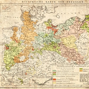
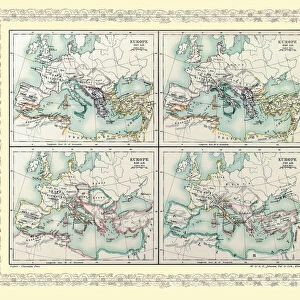
Photographic Print : MAP OF EUROPE IN 1519


![]()
Photo Prints From Universal Images Group (UIG)
MAP OF EUROPE IN 1519
Universal Images Group (UIG) manages distribution for many leading specialist agencies worldwide
Media ID 20165141
© Universal Images Group
1519 1872 Engraving Heir Nineteenth Century Map Wandering
10"x8" Photo Print
Discover history with Media Storehouse's exclusive collection of photographic prints. This captivating piece features a detailed map of Europe in 1519, as originally documented by the Universal History Archive (UIG) under reference number 000035 from Universal Images Group. Travel back in time and explore the political landscape of Europe during the Renaissance era. Each print is produced using premium quality materials and processes to ensure vibrant colors and sharp details. Bring history into your home or office with this intriguing and educational addition to your décor.
Photo prints are produced on Kodak professional photo paper resulting in timeless and breath-taking prints which are also ideal for framing. The colors produced are rich and vivid, with accurate blacks and pristine whites, resulting in prints that are truly timeless and magnificent. Whether you're looking to display your prints in your home, office, or gallery, our range of photographic prints are sure to impress. Dimensions refers to the size of the paper in inches.
Our Photo Prints are in a large range of sizes and are printed on Archival Quality Paper for excellent colour reproduction and longevity. They are ideal for framing (our Framed Prints use these) at a reasonable cost. Alternatives include cheaper Poster Prints and higher quality Fine Art Paper, the choice of which is largely dependant on your budget.
Estimated Product Size is 25.4cm x 20.3cm (10" x 8")
These are individually made so all sizes are approximate
Artwork printed orientated as per the preview above, with landscape (horizontal) or portrait (vertical) orientation to match the source image.
FEATURES IN THESE COLLECTIONS
> Animals
> Fishes
> G
> Grouper
> Maps and Charts
> Related Images
EDITORS COMMENTS
This print showcases a meticulously detailed map of Europe in the year 1519, offering us a fascinating glimpse into the continent's geopolitical landscape during that time. The engraving, created in the nineteenth century style, beautifully captures the essence of historic art and culture. With its intricate illustrative technique and vintage appeal, this piece transports us back to an era when cartography was both an art form and a means of understanding the world. The map itself is a testament to human curiosity and exploration, as it depicts various countries, cities, rivers, mountains, and other geographical features with remarkable accuracy for its time. It serves as a visual heirloom that reminds us of our ancestors' thirst for knowledge and their tireless efforts to navigate uncharted territories. The retro-styled engravement exudes Victorian charm while evoking a sense of wanderlust within us. As we examine each delicate line etched onto paper with care by skilled hands from centuries ago, we can't help but feel connected to those who came before us. This extraordinary image from Universal History Archive is not just an ordinary photograph; it is an artistic masterpiece that invites contemplation on history's vast tapestry. Whether you are an enthusiast of historical artifacts or simply captivated by European heritage, this print will undoubtedly add depth and character to any space it graces.
MADE IN THE USA
Safe Shipping with 30 Day Money Back Guarantee
FREE PERSONALISATION*
We are proud to offer a range of customisation features including Personalised Captions, Color Filters and Picture Zoom Tools
SECURE PAYMENTS
We happily accept a wide range of payment options so you can pay for the things you need in the way that is most convenient for you
* Options may vary by product and licensing agreement. Zoomed Pictures can be adjusted in the Basket.