Photographic Print > Universal Images Group (UIG) > Art > Painting, Sculpture & Prints > Cartography
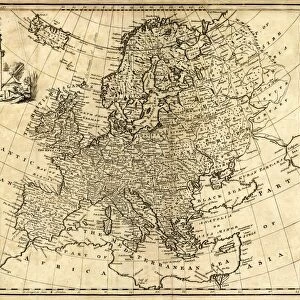
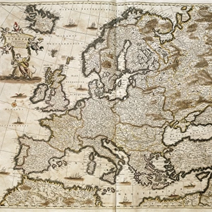
Photographic Print : Europe, from Atlas of the World in thirty-three Maps, by Battista Agnese, 1553


![]()
Photo Prints From Universal Images Group (UIG)
Europe, from Atlas of the World in thirty-three Maps, by Battista Agnese, 1553
Cartography, 16th century. Europe, from Atlas of the World in thirty-three Maps, by Battista Agnese, 1553
Universal Images Group (UIG) manages distribution for many leading specialist agencies worldwide
Media ID 9503547
© DEA / A. DAGLI ORTI
10"x8" Photo Print
Step back in time with our exquisite Media Storehouse range of Photographic Prints, featuring this stunning 16th-century map of Europe from Battista Agnese's Atlas of the World in thirty-three Maps, published in 1553. Meticulously captured from the original Universal Images Group (UIG) archive, this captivating cartographic masterpiece showcases Europe as it was known during the Renaissance era. Add an air of historical charm to your home or office with this beautiful, museum-quality print, a unique addition to any collection.
Photo prints are produced on Kodak professional photo paper resulting in timeless and breath-taking prints which are also ideal for framing. The colors produced are rich and vivid, with accurate blacks and pristine whites, resulting in prints that are truly timeless and magnificent. Whether you're looking to display your prints in your home, office, or gallery, our range of photographic prints are sure to impress. Dimensions refers to the size of the paper in inches.
Our Photo Prints are in a large range of sizes and are printed on Archival Quality Paper for excellent colour reproduction and longevity. They are ideal for framing (our Framed Prints use these) at a reasonable cost. Alternatives include cheaper Poster Prints and higher quality Fine Art Paper, the choice of which is largely dependant on your budget.
Estimated Product Size is 25.4cm x 20.3cm (10" x 8")
These are individually made so all sizes are approximate
Artwork printed orientated as per the preview above, with landscape (horizontal) or portrait (vertical) orientation to match the source image.
EDITORS COMMENTS
This print showcases a remarkable piece of history, taking us back to the 16th century and immersing us in the world of cartography. The image features an antique map titled "Europe" from the renowned Atlas of the World in thirty-three Maps, meticulously crafted by Battista Agnese in 1553. With its horizontal orientation, this illustration and painting transports us into a bygone era when exploration was at its peak and knowledge about our planet was rapidly expanding. The intricate details on this map offer a glimpse into how Europe was perceived during that time, providing valuable insights into both geographical accuracy and cultural representation. As we admire this stunning artwork, it is important to note that there are no people depicted here; instead, our focus is solely on the landmasses themselves. This allows us to appreciate Agnese's mastery as he skillfully captures Europe's diverse topography with precision and elegance. The significance of this print lies not only in its historical value but also in its artistic merit. It serves as a testament to human curiosity and ingenuity while reminding us of the importance placed on understanding our world centuries ago. Acquiring this print from Universal Images Group (UIG) grants us access to an extraordinary artifact that bridges past and present. Let it transport you through time as you marvel at one man's contribution to cartography – an enduring legacy preserved within these delicate lines and colors.
MADE IN THE USA
Safe Shipping with 30 Day Money Back Guarantee
FREE PERSONALISATION*
We are proud to offer a range of customisation features including Personalised Captions, Color Filters and Picture Zoom Tools
SECURE PAYMENTS
We happily accept a wide range of payment options so you can pay for the things you need in the way that is most convenient for you
* Options may vary by product and licensing agreement. Zoomed Pictures can be adjusted in the Basket.