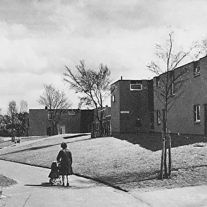
Photographic Print > Europe > United Kingdom > Scotland > Strathclyde > Cumbernauld
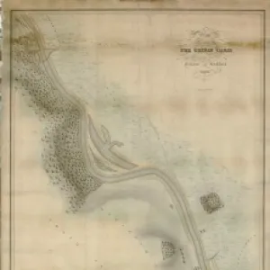
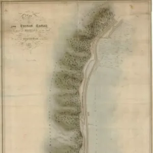
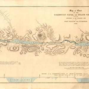
Photographic Print : Plan of the Canal through Dollatur Bog with the adjoining lands


![]()
Photo Prints From Scottish Canals
Plan of the Canal through Dollatur Bog with the adjoining lands
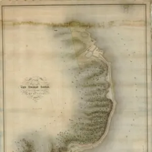
Plan of the Forth and Clyde Canal through Dullatur, Cumbernauld, surveyed by Hugh Baird and copied by Nicol H. Baird
Scottish Canals are in charge of the five canals in Scotland
Media ID 14786771
© Scottish Canals
12"x8" Photo Print
Step back in time with our exquisite Media Storehouse Photographic Print of the Plan of the Canal through Dollatur Bog. This stunning historical image, surveyed by Hugh Baird and copied by Nicol H. Baird, offers a captivating glimpse into Scotland's rich industrial past. The meticulously detailed map showcases the Forth and Clyde Canal, with its winding path through the lush landscape of Cumbernauld. A must-have for history enthusiasts, collectors, or anyone who appreciates the beauty of Scotland's heritage. Experience the history, bring it home.
Photo prints are produced on Kodak professional photo paper resulting in timeless and breath-taking prints which are also ideal for framing. The colors produced are rich and vivid, with accurate blacks and pristine whites, resulting in prints that are truly timeless and magnificent. Whether you're looking to display your prints in your home, office, or gallery, our range of photographic prints are sure to impress. Dimensions refers to the size of the paper in inches.
Our Photo Prints are in a large range of sizes and are printed on Archival Quality Paper for excellent colour reproduction and longevity. They are ideal for framing (our Framed Prints use these) at a reasonable cost. Alternatives include cheaper Poster Prints and higher quality Fine Art Paper, the choice of which is largely dependant on your budget.
Estimated Image Size (if not cropped) is 30.4cm x 6.6cm (12" x 2.6")
Estimated Product Size is 30.5cm x 20.3cm (12" x 8")
These are individually made so all sizes are approximate
Artwork printed orientated as per the preview above, with landscape (horizontal) orientation to match the source image.
FEATURES IN THESE COLLECTIONS
> Europe
> United Kingdom
> Scotland
> Posters
> Europe
> United Kingdom
> Scotland
> Related Images
> Europe
> United Kingdom
> Scotland
> Strathclyde
> Cumbernauld
EDITORS COMMENTS
This print showcases the intricate "Plan of the Canal through Dollatur Bog with the adjoining lands" in all its historical glory. Surveyed by Hugh Baird and meticulously copied by Nicol H. Baird, this remarkable plan depicts the route of the Forth and Clyde Canal as it traverses through Dullatur and Cumbernauld in Scotland. The image transports us back to a time when canals were vital lifelines for transportation and trade. The attention to detail is awe-inspiring, capturing every twist and turn of this engineering marvel that connected two major bodies of water - the Firth of Forth on Scotland's east coast and the River Clyde on its west coast. As we gaze upon this photo print, we cannot help but appreciate both its artistic value and historical significance. It serves as a testament to human ingenuity, showcasing how individuals like Hugh Baird dedicated their skills to shaping landscapes for societal progress. Beyond its aesthetic appeal, this photograph holds immense educational value too. It offers a glimpse into an era when canals played a pivotal role in transforming local economies while fostering cultural exchange between regions. Scottish Canals preserves such treasures not only for commercial purposes but also as valuable artifacts that connect us with our past. This particular print invites us to reflect on our rich heritage while appreciating how far we have come since those early days of canal construction.
MADE IN THE USA
Safe Shipping with 30 Day Money Back Guarantee
FREE PERSONALISATION*
We are proud to offer a range of customisation features including Personalised Captions, Color Filters and Picture Zoom Tools
SECURE PAYMENTS
We happily accept a wide range of payment options so you can pay for the things you need in the way that is most convenient for you
* Options may vary by product and licensing agreement. Zoomed Pictures can be adjusted in the Basket.