Photographic Print > Europe > United Kingdom > Scotland > Maps
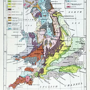
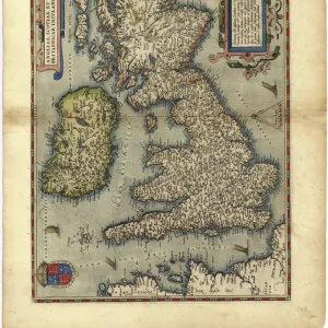
Photographic Print : Geological map of the British Islands


![]()
Photo Prints from Mary Evans Picture Library
Geological map of the British Islands
Geological map of the British Islands.
1941
Mary Evans Picture Library makes available wonderful images created for people to enjoy over the centuries
Media ID 23090632
© Mary Evans Picture Library/Onslow Auctions Limited
1941 Coded Coding Geological Geology Isles Maps Office Ordnance Survey
10"x8" Photo Print
Discover the fascinating geological history of the British Isles with our stunning print from Mary Evans Picture Library/Onslow Auctions Limited. This rare and captivating Geological map of the British Islands, published in 1941, offers a unique perspective on the intricacies of the land beneath our feet. With intricate detail and vibrant colors, this print is not only a beautiful addition to any home or office, but also a valuable educational resource for geology enthusiasts and history buffs alike. Explore the rich geological history of the British Isles with this exquisite print from Media Storehouse.
Photo prints are produced on Kodak professional photo paper resulting in timeless and breath-taking prints which are also ideal for framing. The colors produced are rich and vivid, with accurate blacks and pristine whites, resulting in prints that are truly timeless and magnificent. Whether you're looking to display your prints in your home, office, or gallery, our range of photographic prints are sure to impress. Dimensions refers to the size of the paper in inches.
Our Photo Prints are in a large range of sizes and are printed on Archival Quality Paper for excellent colour reproduction and longevity. They are ideal for framing (our Framed Prints use these) at a reasonable cost. Alternatives include cheaper Poster Prints and higher quality Fine Art Paper, the choice of which is largely dependant on your budget.
Estimated Image Size (if not cropped) is 18.4cm x 25.4cm (7.2" x 10")
Estimated Product Size is 20.3cm x 25.4cm (8" x 10")
These are individually made so all sizes are approximate
Artwork printed orientated as per the preview above, with portrait (vertical) orientation to match the source image.
FEATURES IN THESE COLLECTIONS
> Mary Evans Prints Online
> New Images August 2021
> Animals
> Mammals
> Muridae
> Fortior
> Europe
> Republic of Ireland
> Maps
> Europe
> United Kingdom
> England
> Maps
> Europe
> United Kingdom
> England
> Posters
> Europe
> United Kingdom
> England
> Related Images
> Europe
> United Kingdom
> Maps
> Europe
> United Kingdom
> Scotland
> Maps
> Europe
> United Kingdom
> Scotland
> Posters
> Europe
> United Kingdom
> Scotland
> Related Images
> Europe
> United Kingdom
> Wales
> Maps
EDITORS COMMENTS
1. Title: "Exploring the Past: A Vintage Geological Map of the British Islands (1941)" This vintage geological map print showcases the intricate geological makeup of the British Islands, including England, Wales, Scotland, and Ireland. Dated back to 1941, this poster-sized map is a testament to the meticulous work of the Ordnance Survey Office during the 1940s. The map is adorned with a rich, vibrant color palette, with each geological formation coded with a distinct hue. The coding system used in this map allows viewers to easily identify and understand the various geological formations that underlie the British Isles. The map's intricate detailing reveals the complex geological history of the region, from the ancient Precambrian rocks to the more recent Quaternary deposits. The map also highlights notable geological features such as fault lines, volcanic formations, and mineral deposits. This map is not only a valuable resource for geologists and earth scientists but also an intriguing piece of historical cartography. It offers a unique glimpse into the past, providing insights into the scientific understanding of the British Isles during the 1940s. The map's age adds to its allure, making it a fascinating addition to any home or office space. Whether used as a decorative piece or a tool for research, this vintage geological map of the British Islands is sure to captivate and inspire. This image is available for licensing through Mary Evans Picture Library/Onslow Auctions Limited from Mary Evans Prints Online.
MADE IN THE USA
Safe Shipping with 30 Day Money Back Guarantee
FREE PERSONALISATION*
We are proud to offer a range of customisation features including Personalised Captions, Color Filters and Picture Zoom Tools
SECURE PAYMENTS
We happily accept a wide range of payment options so you can pay for the things you need in the way that is most convenient for you
* Options may vary by product and licensing agreement. Zoomed Pictures can be adjusted in the Cart.