Photographic Print > Europe > France > Canton > Landes
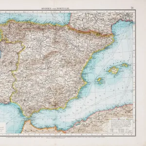
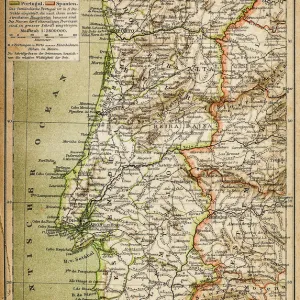
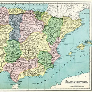
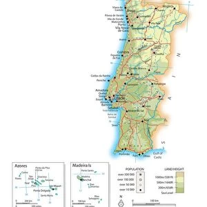
Photographic Print : Map of Spain and Portugal


![]()
Photo Prints from Mary Evans Picture Library
Map of Spain and Portugal
Map of Spain and Portugal, with part of southern France and northern Africa. Date: circa 1801
Mary Evans Picture Library makes available wonderful images created for people to enjoy over the centuries
Media ID 14262704
© Mary Evans / Pharcide
1800s 1801 Atlantic Balearic Biscay Continent Continental Majorca Maps Minorca Portugal Portuguese
10"x8" Photo Print
Discover the rich history and cultural connections between Spain and Portugal with our stunning Map of Spain and Portugal print from Media Storehouse. This exquisite, rights-managed reproduction, sourced from Mary Evans Prints Online, dates back to circa 1801. With intricate detail, this map reveals the borders, geographical features, and historical context of the Iberian Peninsula, as well as parts of southern France and northern Africa. Bring this piece of history into your home or office and elevate the decor with a touch of classic cartography and world exploration.
Photo prints are produced on Kodak professional photo paper resulting in timeless and breath-taking prints which are also ideal for framing. The colors produced are rich and vivid, with accurate blacks and pristine whites, resulting in prints that are truly timeless and magnificent. Whether you're looking to display your prints in your home, office, or gallery, our range of photographic prints are sure to impress. Dimensions refers to the size of the paper in inches.
Our Photo Prints are in a large range of sizes and are printed on Archival Quality Paper for excellent colour reproduction and longevity. They are ideal for framing (our Framed Prints use these) at a reasonable cost. Alternatives include cheaper Poster Prints and higher quality Fine Art Paper, the choice of which is largely dependant on your budget.
Estimated Product Size is 25.4cm x 20.3cm (10" x 8")
These are individually made so all sizes are approximate
Artwork printed orientated as per the preview above, with landscape (horizontal) orientation to match the source image.
FEATURES IN THESE COLLECTIONS
> Africa
> Related Images
> Africa
> South Africa
> Maps
> Africa
> South Africa
> Related Images
> Animals
> Mammals
> Muridae
> Water Mouse
> Arts
> Artists
> O
> Oceanic Oceanic
> Europe
> France
> Canton
> Landes
> Europe
> Portugal
> Related Images
EDITORS COMMENTS
1. Title: A Glimpse into the Past: The 1801 Map of Spain, Portugal, and Surrounding Regions This map print, dated circa 1801, offers a fascinating glimpse into the geography and political landscape of Europe during the early 19th century. The map focuses on the Iberian Peninsula, showcasing the intricate details of the coastlines of Spain and Portugal, as well as parts of southern France and northern Africa. The map's vibrant colors and meticulously drawn borders highlight the distinct territories of Spain and Portugal, with their rich histories and diverse cultures. The Atlantic Ocean and the Bay of Biscay stretch out to the west, providing a vital connection to the New World and the world beyond. The Balearic Islands, including Majorca and Minorca, are clearly visible in the Mediterranean Sea, while the North African coastline reveals the strategic importance of the straits of Gibraltar and the presence of Spanish and Portuguese colonies. This period marked the height of European colonialism, with Spain and Portugal holding significant territories in the Americas and Africa. The map's intricate details provide valuable insights into the geography and political landscape of the time. The mountain ranges, rivers, and bays are all accurately depicted, making it an essential resource for historians, geographers, and anyone interested in the history of Europe and its exploration. This map serves as a captivating reminder of the rich history and complex geography of the Iberian Peninsula and its surrounding regions during the 1800s. It invites us to explore the stories of the people, cultures, and events that shaped the world as we know it today.
MADE IN THE USA
Safe Shipping with 30 Day Money Back Guarantee
FREE PERSONALISATION*
We are proud to offer a range of customisation features including Personalised Captions, Color Filters and Picture Zoom Tools
SECURE PAYMENTS
We happily accept a wide range of payment options so you can pay for the things you need in the way that is most convenient for you
* Options may vary by product and licensing agreement. Zoomed Pictures can be adjusted in the Cart.