Photographic Print > Asia > Turkey > Related Images
Photographic Print : Map of Greece, 1792


![]()
Photo Prints from Mary Evans Picture Library
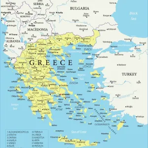
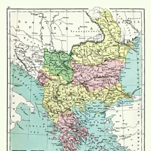
Map of Greece, 1792
Map of Greece and Greek islands plus Romania (which appears on this map to be incorrectly labelled or positioned south of Bulgaria), Macedonia, Albania and parts of Turkey and Italy. (Detail of image 10074527) Date: 1792
Mary Evans Picture Library makes available wonderful images created for people to enjoy over the centuries
Media ID 7188023
© Mary Evans Picture Library 2015 - https://copyrighthub.org/s0/hub1/creation/maryevans/MaryEvansPictureID/10527528
1790s 1792 Albania Macedonia Maps Romania
10"x8" Photo Print
Discover history through the lens with our exclusive range of Media Storehouse Photographic Prints. This captivating antique map, titled "Map of Greece, 1792," is a rare find from the Mary Evans Prints Online archive. Depicting Greece and its neighboring regions including Albania, Romania (incorrectly labeled or positioned), Macedonia, Turkey, and Italy, this print offers a fascinating glimpse into the geographical understanding of the world over two centuries ago. Add this beautifully detailed and historically significant piece to your collection and let the stories of the past unfold.
Photo prints are produced on Kodak professional photo paper resulting in timeless and breath-taking prints which are also ideal for framing. The colors produced are rich and vivid, with accurate blacks and pristine whites, resulting in prints that are truly timeless and magnificent. Whether you're looking to display your prints in your home, office, or gallery, our range of photographic prints are sure to impress. Dimensions refers to the size of the paper in inches.
Our Photo Prints are in a large range of sizes and are printed on Archival Quality Paper for excellent colour reproduction and longevity. They are ideal for framing (our Framed Prints use these) at a reasonable cost. Alternatives include cheaper Poster Prints and higher quality Fine Art Paper, the choice of which is largely dependant on your budget.
Estimated Product Size is 25.4cm x 20.3cm (10" x 8")
These are individually made so all sizes are approximate
Artwork printed orientated as per the preview above, with landscape (horizontal) orientation to match the source image.
FEATURES IN THESE COLLECTIONS
> Asia
> Turkey
> Related Images
> Europe
> Albania
> Related Images
> Europe
> Bulgaria
> Related Images
> Europe
> Greece
> Related Images
EDITORS COMMENTS
1. Title: "An 18th Century Vision of Greece and its Neighbors: A Historical Examination of the 1792 Map of Greece, Romania, Macedonia, Albania, Turkey, and Italy" 2.. This map print, dating back to 1792, offers a fascinating glimpse into Europe's historical geography. The map, which is part of a larger work, depicts Greece, Greek islands, Romania, Macedonia, Albania, parts of Turkey, and Italy. The intricate detail and vibrant colors of this map transport us back in time, allowing us to explore the political and geographical landscape of the 18th century. 3. Context: The map, produced in the late 18th century, reflects the geographical knowledge and understanding of the time. While it accurately portrays much of Greece, the inclusion of Romania in a position south of Bulgaria is an intriguing anomaly. This misplacement of Romania is likely due to the evolving nature of European cartography during this period, as borders and territories were still being defined and redefined. 4. Historical Significance: The map provides valuable context for understanding the political and geographical landscape of Europe during the 1790s. Greece, which was then under Ottoman rule, is depicted in detail, along with its neighboring countries. The map also highlights the complex interplay of territories and borders, which would later be redrawn in the wake of the French Revolution and the subsequent political upheavals in Europe. 5. Conclusion: This beautiful and intriguing map print serves as a reminder of the rich historical tapestry that underpins our contemporary understanding of Europe's geography. By examining the map's details and anomalies, we can gain valuable insights into the political, cultural, and cartographic developments of the 18th century. Whether used for educational or decorative purposes, this map is a captivating reminder of the past and a testament to the enduring power of historical cartography.
MADE IN THE USA
Safe Shipping with 30 Day Money Back Guarantee
FREE PERSONALISATION*
We are proud to offer a range of customisation features including Personalised Captions, Color Filters and Picture Zoom Tools
SECURE PAYMENTS
We happily accept a wide range of payment options so you can pay for the things you need in the way that is most convenient for you
* Options may vary by product and licensing agreement. Zoomed Pictures can be adjusted in the Cart.