Photographic Print > Maps and Charts > Early Maps
Photographic Print : Atlantis / Map


![]()
Photo Prints from Mary Evans Picture Library
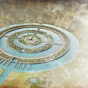
Atlantis / Map
Map showing Atlantis during the period of its greatest prosperity
Mary Evans Picture Library makes available wonderful images created for people to enjoy over the centuries
Media ID 577911
© Mary Evans Picture Library 2015 - https://copyrighthub.org/s0/hub1/creation/maryevans/MaryEvansPictureID/10018417
1896 Atlantis Folk Lore Greatest Mythical Places Prosperity
10"x8" Photo Print
Discover the mystical world of Atlantis with our stunning photographic print from Mary Evans Picture Library. This captivating image, titled "Atlantis / Map," transports you back in time to the legendary city's period of greatest prosperity. With intricate details and vivid colors, this print is a must-have for history enthusiasts, mythology lovers, and anyone who appreciates the beauty of ancient cartography. Bring the enchanting story of Atlantis to life in your home or office with this unique and intriguing piece of art. Order your Mary Evans Prints Online photographic print of "Atlantis / Map" today and let your imagination soar.
Photo prints are produced on Kodak professional photo paper resulting in timeless and breath-taking prints which are also ideal for framing. The colors produced are rich and vivid, with accurate blacks and pristine whites, resulting in prints that are truly timeless and magnificent. Whether you're looking to display your prints in your home, office, or gallery, our range of photographic prints are sure to impress. Dimensions refers to the size of the paper in inches.
Our Photo Prints are in a large range of sizes and are printed on Archival Quality Paper for excellent colour reproduction and longevity. They are ideal for framing (our Framed Prints use these) at a reasonable cost. Alternatives include cheaper Poster Prints and higher quality Fine Art Paper, the choice of which is largely dependant on your budget.
Estimated Product Size is 25.4cm x 20.3cm (10" x 8")
These are individually made so all sizes are approximate
Artwork printed orientated as per the preview above, with landscape (horizontal) orientation to match the source image.
FEATURES IN THESE COLLECTIONS
> Maps and Charts
> Early Maps
> Maps and Charts
> Related Images
EDITORS COMMENTS
This stunning print from Mary Evans Picture Library showcases a detailed map of Atlantis during the period of its greatest prosperity. The map, dating back to 1896, offers a glimpse into the historical and mythical world of this legendary civilization.
The intricate details on the map bring to life the places and landmarks that once existed in Atlantis, as described in ancient folklore and history. From grand palaces to bustling marketplaces, this depiction captures the essence of a thriving society at its peak.
As viewers study the map, they are transported back in time to an era filled with wonder and mystery. The rich tapestry of colors and symbols on display hint at the advanced culture that once flourished in this mythical land.
Whether you are a history buff or simply intrigued by tales of lost civilizations, this print is sure to captivate your imagination. It serves as a reminder of the enduring fascination with Atlantis and its place in our collective consciousness.
With Mary Evans Prints Online's high-quality reproduction, you can now own a piece of this enigmatic legend for yourself. Display it proudly in your home or office as a conversation starter and source of inspiration for exploring new worlds – both real and imagined.
MADE IN THE USA
Safe Shipping with 30 Day Money Back Guarantee
FREE PERSONALISATION*
We are proud to offer a range of customisation features including Personalised Captions, Color Filters and Picture Zoom Tools
SECURE PAYMENTS
We happily accept a wide range of payment options so you can pay for the things you need in the way that is most convenient for you
* Options may vary by product and licensing agreement. Zoomed Pictures can be adjusted in the Cart.