Photographic Print > Arts > Photorealistic artworks > Meticulous attention to detail > Detailed artwork
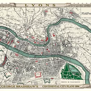
Photographic Print : George Bradshaws Plan of Marseilles, France 1896

![]()
Photo Prints from MapSeeker
George Bradshaws Plan of Marseilles, France 1896
This is a detailed Plan of the Port and City of Marseilles showing the streets, canals, principal buildings, railways and railway stations. There is a comprehensive list of Places of Interest numerically illustrated with the plan. It has been meticulously recreated in colour and republished without and fold creases by Mapseeker, from a rare antique original black and white fold up tourist city map. The 29 that were originally published as fold up maps featuring the principal cities of Europe are now rare, yet popular at their time among those who could then explore Europe by railway for the first time
Welcome to the Mapseeker Image library and enter an historic gateway to one of the largest on-line collections of Historic Maps, Nostalgic Views, Vista's and Panorama's from a World gone by.
Media ID 20347947
© Mapseeker Publishing Ltd
Bradshaw City Map Bradshaw City Plan Bradshaw Map Europe City Europe City Plan European City Map European City Plan Historic Map Old Town Plan French City Marseilles
11"x8.5" Photo Print
Discover the rich history of Marseilles, France with this stunning photographic print from Media Storehouse. Featuring George Bradshaw's intricately detailed "Plan of Marseilles, France 1896" published by MapSeeker Publishing Ltd, this print showcases the Port and City in exquisite detail. Explore the streets, canals, principal buildings, railways, and railway stations of Marseilles as they appeared over a century ago. A must-have for history enthusiasts and collectors, this photographic print makes a beautiful addition to any home or office space.
Photo prints are produced on Kodak professional photo paper resulting in timeless and breath-taking prints which are also ideal for framing. The colors produced are rich and vivid, with accurate blacks and pristine whites, resulting in prints that are truly timeless and magnificent. Whether you're looking to display your prints in your home, office, or gallery, our range of photographic prints are sure to impress. Dimensions refers to the size of the paper in inches.
Our Photo Prints are in a large range of sizes and are printed on Archival Quality Paper for excellent colour reproduction and longevity. They are ideal for framing (our Framed Prints use these) at a reasonable cost. Alternatives include cheaper Poster Prints and higher quality Fine Art Paper, the choice of which is largely dependant on your budget.
Estimated Image Size (if not cropped) is 27.9cm x 18.6cm (11" x 7.3")
Estimated Product Size is 27.9cm x 21.6cm (11" x 8.5")
These are individually made so all sizes are approximate
Artwork printed orientated as per the preview above, with landscape (horizontal) orientation to match the source image.
FEATURES IN THESE COLLECTIONS
> MapSeeker
> Maps of Europe
> Maps of France PORTFOLIO
> Arts
> Artists
> W
> George White
> Arts
> Modern art pieces
> Pop art
> Street art
> Arts
> Photorealistic artworks
> Detailed art pieces
> Masterful detailing in art
> Arts
> Photorealistic artworks
> Meticulous attention to detail
> Detailed artwork
> Arts
> Photorealistic artworks
> Meticulous attention to detail
> Fine art
> Europe
> France
> Marseilles
EDITORS COMMENTS
This beautifully restored print of "George Bradshaw's Plan of Marseilles, France 1896" offers a captivating glimpse into the past. The intricate details showcased in this city map allow us to explore the bustling streets, canals, and principal buildings that once defined Marseilles. Originally published as a fold-up tourist map, these rare pieces were highly sought after by adventurous souls who embarked on their European journeys via railway. MapSeeker Publishing Ltd has meticulously recreated this historic gem in vivid color, ensuring that no fold creases mar its visual appeal. This reproduction faithfully captures the essence of the original black and white map while breathing new life into it for contemporary admirers. The comprehensive list of numerically illustrated Places of Interest adds an extra layer of intrigue to this remarkable piece. It invites us to imagine strolling through the vibrant streets and discovering hidden gems within one of France's most iconic cities. As we gaze upon this old town plan from 1896, we are transported back in time to an era when rail travel was revolutionizing how people explored Europe. George Bradshaw's meticulous attention to detail allows us to appreciate not only the beauty but also the historical significance embedded within each street corner and railway station depicted on this map. Whether you're a history enthusiast or simply captivated by vintage cartography, "George Bradshaw's Plan of Marseilles" is sure to ignite your imagination and transport you on a journey through time.
MADE IN THE USA
Safe Shipping with 30 Day Money Back Guarantee
FREE PERSONALISATION*
We are proud to offer a range of customisation features including Personalised Captions, Color Filters and Picture Zoom Tools
SECURE PAYMENTS
We happily accept a wide range of payment options so you can pay for the things you need in the way that is most convenient for you
* Options may vary by product and licensing agreement. Zoomed Pictures can be adjusted in the Cart.