Photographic Print > Europe > United Kingdom > Scotland > Edinburgh > Edinburgh
Photographic Print : Old County Map of Edinburgh Scotland 1847 by A&C Black


![]()
Photo Prints From MapSeeker
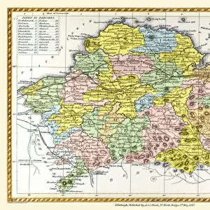
Old County Map of Edinburgh Scotland 1847 by A&C Black
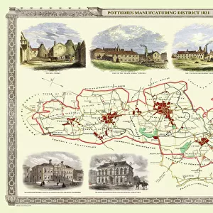
A finely detailed facimile remastered in full colour from an antique original map of Edinburgh featured in A&C Blacks Atlas of 1847. Each Parish is numbered using an index table, colour rendition beautifully differentiating all of the Parishes. As well as principal roads, towns, villages and hamlets, these county maps of Scotland feature key battle sites marked with two crossed swords and the date of the battle
Welcome to the Mapseeker Image library and enter an historic gateway to one of the largest on-line collections of Historic Maps, Nostalgic Views, Vista's and Panorama's from a World gone by.
Media ID 20347451
© Mapseeker Publishing Ltd
A And C Black A And C Black Atlas A And C Black Map County Map County Map Of Scotland Edinburgh Historic Map Old County Map Old Scottish County Map Scottish County Map
12"x8" Photo Print
Step back in time with our Old County Map of Edinburgh Scotland 1847 by A&C Black from the Media Storehouse range of Photographic Prints. This exquisite map, remastered in full color from an antique original found in A&C Black's Atlas of 1847, offers a fascinating glimpse into the history and layout of Edinburgh over 170 years ago. With finely detailed features and intricate cartography, this print makes a beautiful addition to any home or office, transporting you to a bygone era. Order now and bring a piece of the past into your space.
Photo prints are produced on Kodak professional photo paper resulting in timeless and breath-taking prints which are also ideal for framing. The colors produced are rich and vivid, with accurate blacks and pristine whites, resulting in prints that are truly timeless and magnificent. Whether you're looking to display your prints in your home, office, or gallery, our range of photographic prints are sure to impress. Dimensions refers to the size of the paper in inches.
Our Photo Prints are in a large range of sizes and are printed on Archival Quality Paper for excellent colour reproduction and longevity. They are ideal for framing (our Framed Prints use these) at a reasonable cost. Alternatives include cheaper Poster Prints and higher quality Fine Art Paper, the choice of which is largely dependant on your budget.
Estimated Product Size is 30.5cm x 20.3cm (12" x 8")
These are individually made so all sizes are approximate
Artwork printed orientated as per the preview above, with landscape (horizontal) orientation to match the source image.
FEATURES IN THESE COLLECTIONS
> Arts
> Photorealistic artworks
> Detailed art pieces
> Masterful detailing in art
> Europe
> United Kingdom
> Heritage Sites
> Old and New Towns of Edinburgh
> Europe
> United Kingdom
> Scotland
> Edinburgh
> Edinburgh
> Europe
> United Kingdom
> Scotland
> Edinburgh
> Europe
> United Kingdom
> Scotland
> Lothian
> Edinburgh
> Europe
> United Kingdom
> Scotland
> Maps
> Maps and Charts
> Early Maps
EDITORS COMMENTS
This stunning print showcases the "Old County Map of Edinburgh Scotland 1847" by A&C Black. Remastered in full color, this finely detailed facsimile brings to life an antique original map featured in A&C Blacks Atlas of 1847. What sets this map apart is its meticulous attention to detail and vibrant color rendition, beautifully differentiating each Parish with a unique hue. As you explore the map, you'll discover not only principal roads, towns, villages, and hamlets but also significant battle sites marked with two crossed swords and the date of each historic clash. Transporting us back in time, this old Scottish county map offers a captivating glimpse into Edinburgh's rich history. It allows us to trace the evolution of this iconic city while unraveling its intricate tapestry of Parishes and landmarks. Whether you're a history enthusiast or simply appreciate the beauty of cartography, this historic map will undoubtedly captivate your imagination. Its visual storytelling transcends mere geography as it unravels centuries-old tales etched upon Edinburgh's streets. A true testament to A&C Black's craftsmanship and dedication to preserving historical treasures through their atlas collection. This print serves as both a decorative piece for any wall space and a gateway into Edinburgh's past—a timeless tribute that connects us with our roots while celebrating the enduring allure of maps themselves.
MADE IN THE USA
Safe Shipping with 30 Day Money Back Guarantee
FREE PERSONALISATION*
We are proud to offer a range of customisation features including Personalised Captions, Color Filters and Picture Zoom Tools
SECURE PAYMENTS
We happily accept a wide range of payment options so you can pay for the things you need in the way that is most convenient for you
* Options may vary by product and licensing agreement. Zoomed Pictures can be adjusted in the Basket.