Photographic Print > Europe > United Kingdom > England > London > Towns > Welling
Photographic Print : Old County Map of Rutlandshire 1836 by Thomas Moule


![]()
Photo Prints from MapSeeker
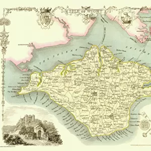
Old County Map of Rutlandshire 1836 by Thomas Moule
This is a fine decorative reproduction County Map of Rutlandshire from the First Edition series of Thomas Moule Maps, originally Published in 1836. The well-known series of County Maps which are known as Moules feature beautiful vignette views and were first published in separate sections for each county in 1830-32, they were then published in collected form in a two-volume work: The English Counties Delineated: or a Topographical Description of England: Illustrated by a Complete Series of County Maps by Thomas Moule: London: Published by George Virtue 1836
Welcome to the Mapseeker Image library and enter an historic gateway to one of the largest on-line collections of Historic Maps, Nostalgic Views, Vista's and Panorama's from a World gone by.
Media ID 20347927
© Mapseeker Publishing Ltd
County Map County Map Of England English County Map Historic Map Moule Map Old County Map Old English County Map Old Moule Map Thomas Moule Thomas Moule Map Rutlandshire
10"x8" Photo Print
Step back in time with our exquisite Old County Map of Rutlandshire 1836 by Thomas Moule. This decorative reproduction map, published by MapSeeker, transports you to the past with intricate detail and authenticity. Originally created by Thomas Moule and George Virtue in 1836, this first edition map of Rutlandshire is a true piece of historical art. Add a touch of nostalgia and charm to your home or office with this beautifully detailed and authentic reproduction map.
Photo prints are produced on Kodak professional photo paper resulting in timeless and breath-taking prints which are also ideal for framing. The colors produced are rich and vivid, with accurate blacks and pristine whites, resulting in prints that are truly timeless and magnificent. Whether you're looking to display your prints in your home, office, or gallery, our range of photographic prints are sure to impress. Dimensions refers to the size of the paper in inches.
Our Photo Prints are in a large range of sizes and are printed on Archival Quality Paper for excellent colour reproduction and longevity. They are ideal for framing (our Framed Prints use these) at a reasonable cost. Alternatives include cheaper Poster Prints and higher quality Fine Art Paper, the choice of which is largely dependant on your budget.
Estimated Product Size is 20.3cm x 25.4cm (8" x 10")
These are individually made so all sizes are approximate
Artwork printed orientated as per the preview above, with landscape (horizontal) or portrait (vertical) orientation to match the source image.
FEATURES IN THESE COLLECTIONS
> MapSeeker
> Maps from the British Isles
> England and Counties PORTFOLIO
> Arts
> Artists
> M
> Thomas Moule
> Europe
> United Kingdom
> England
> London
> Towns
> Welling
> Europe
> United Kingdom
> England
> Maps
> Europe
> United Kingdom
> England
> Wells
> Maps and Charts
> Early Maps
> Maps and Charts
> Related Images
EDITORS COMMENTS
This beautifully crafted print showcases the "Old County Map of Rutlandshire 1836" by Thomas Moule, a renowned cartographer of his time. Originally published as part of Moule's First Edition series in 1836, this decorative reproduction captures the essence and charm of the historic map. Moule's collection of County Maps is widely recognized for its exquisite vignette views, which add an artistic touch to each piece. The maps were initially released individually for every county between 1830 and 1832 before being compiled into a two-volume work titled "The English Counties Delineated: or a Topographical Description of England: Illustrated by a Complete Series of County Maps". This particular map was included in the second volume published by George Virtue in London in 1836. As you explore this old English county map, you'll be transported back to Rutlandshire's past. Its intricate details provide a fascinating glimpse into the historical landscape and boundaries that shaped this region during the early nineteenth century. Whether you're an avid collector or simply appreciate historical artifacts, this print is sure to captivate your imagination with its rich heritage. Thomas Moule's legacy lives on through his exceptional cartographic works like this one. Displaying it proudly will not only enhance your space but also serve as a reminder of our connection to history and how geography has evolved over time.
MADE IN THE USA
Safe Shipping with 30 Day Money Back Guarantee
FREE PERSONALISATION*
We are proud to offer a range of customisation features including Personalised Captions, Color Filters and Picture Zoom Tools
SECURE PAYMENTS
We happily accept a wide range of payment options so you can pay for the things you need in the way that is most convenient for you
* Options may vary by product and licensing agreement. Zoomed Pictures can be adjusted in the Cart.