Photographic Print > MapSeeker > Maps from the British Isles > British Isles Map PORTFOLIO
Photographic Print : Map of Britain as it appeared in Roman Times


![]()
Photo Prints From MapSeeker
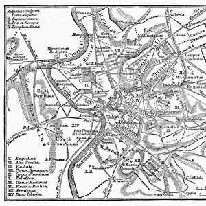
Map of Britain as it appeared in Roman Times
BHISM001
Welcome to the Mapseeker Image library and enter an historic gateway to one of the largest on-line collections of Historic Maps, Nostalgic Views, Vista's and Panorama's from a World gone by.
Media ID 20348217
10"x8" Photo Print
Discover the rich history of Britain with our stunning Map of Britain as it appeared in Roman Times from the Media Storehouse range of Photographic Prints (BHISM001). This captivating image, brought to you by MapSeeker, transports you back in time, allowing you to explore the Roman Empire's influence on the British Isles. With intricate detail and vibrant colours, this photographic print makes a perfect addition to any home or office, igniting curiosity and inspiring conversation. Bring history to life with Media Storehouse.
Photo prints are produced on Kodak professional photo paper resulting in timeless and breath-taking prints which are also ideal for framing. The colors produced are rich and vivid, with accurate blacks and pristine whites, resulting in prints that are truly timeless and magnificent. Whether you're looking to display your prints in your home, office, or gallery, our range of photographic prints are sure to impress. Dimensions refers to the size of the paper in inches.
Our Photo Prints are in a large range of sizes and are printed on Archival Quality Paper for excellent colour reproduction and longevity. They are ideal for framing (our Framed Prints use these) at a reasonable cost. Alternatives include cheaper Poster Prints and higher quality Fine Art Paper, the choice of which is largely dependant on your budget.
Estimated Product Size is 25.4cm x 20.3cm (10" x 8")
These are individually made so all sizes are approximate
Artwork printed orientated as per the preview above, with landscape (horizontal) orientation to match the source image.
EDITORS COMMENTS
This print showcases a mesmerizing glimpse into the past, offering us an extraordinary view of the "Map of Britain as it appeared in Roman Times (BHISM001)". Transporting us back to an era steeped in history and grandeur, this image is a testament to the enduring legacy left by one of the world's most influential civilizations. The map itself is a remarkable work of artistry and precision. Every detail meticulously captured on this print allows us to visualize how Britain looked during its occupation by the mighty Romans. From intricate road networks connecting bustling cities to strategically placed forts guarding frontiers, this map provides invaluable insights into their strategic conquests and cultural influence. As we delve deeper into this visual time capsule, our imagination takes flight. We envision legions marching across vast landscapes, trading caravans traversing ancient routes, and citizens engaging in daily life within thriving Roman settlements. The map reveals not only geographical features but also offers glimpses into social dynamics that shaped Britannia under Roman rule. Beyond its historical significance, this print serves as a reminder of our interconnectedness with those who walked these lands centuries ago. It sparks curiosity about their lives while igniting a desire for further exploration and understanding. In preserving such artifacts through photography, MapSeeker has provided us with an opportunity to appreciate and learn from our shared heritage. This stunning depiction invites us to reflect on Britain's rich past while inspiring future generations to explore history's hidden treasures firsthand.
MADE IN THE USA
Safe Shipping with 30 Day Money Back Guarantee
FREE PERSONALISATION*
We are proud to offer a range of customisation features including Personalised Captions, Color Filters and Picture Zoom Tools
SECURE PAYMENTS
We happily accept a wide range of payment options so you can pay for the things you need in the way that is most convenient for you
* Options may vary by product and licensing agreement. Zoomed Pictures can be adjusted in the Basket.