Photographic Print > Arts > Artists > S > Syrian Syrian
Photographic Print : Section of Route from Diarbekir to Sivas and Sivas to Sinope by Aneroid readings, c1915


![]()
Photo Prints From Heritage Images
Section of Route from Diarbekir to Sivas and Sivas to Sinope by Aneroid readings, c1915
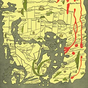
Section of Route from Diarbekir to Sivas and Sivas to Sinope by Aneroid readings, c1915. Map showing the journeys, with altitude above sea level, of British writer, soldier and diplomatic advisor Mark Sykes in Turkey (at that time part of the Ottoman Empire), between 1905 and 1913. Sykes (1879-1919) travelled through Palestine, Iraq, Syria, Persia and Turkey, was honorary attache to the British Embassy in Constantinople 1905-1906, was elected to parliament, worked in the Intelligence department of the War Office during the First World War, and died of the Spanish flu aged 39. From " The Caliphs Last Heritage, a short history of the Turkish Empire" by Lt.-Col. Sir Mark Sykes. [Macmillan & Co, London, 1915]
Heritage Images features heritage image collections
Media ID 19658869
© The Print Collector/Heritage Images
6th Baronet Altitude Altitude Measurement Anatolia Asia Minor Colonel Sir Tatton Benvenuto Mark Sykes Height Lieutenant Colonel Sir Mark Sykes Macmillan Macmillan And Co Macmillan Publishers Macmillan Publishers Ltd Mark Mark Sykes Ottoman Empire Publishers Macmillan Route Sinop Sinope Sir Mark Sykes Stanfords Stanfords Geographical Establishment Sykes Sykes Mark Sykes Mark Sir Sykes Tatton Benvenuto Mark Tatton Benvenuto Mark Tatton Benvenuto Mark Sykes Turkey Turkish Aneroid Sea Level
12"x8" Photo Print
Step back in time with this captivating vintage map print from Media Storehouse. This rare and intriguing piece, sourced from Heritage Images, showcases a section of the historic route from Diarbekir to Sivas and Sivas to Sinope, as recorded by aneroid readings in 1915 by Stanford's Geographical Establishment. The map offers a unique glimpse into the past, with altitude readings adding an extra layer of detail. A must-have for history enthusiasts, travelers, or anyone seeking to add a touch of nostalgia to their decor.
Photo prints are produced on Kodak professional photo paper resulting in timeless and breath-taking prints which are also ideal for framing. The colors produced are rich and vivid, with accurate blacks and pristine whites, resulting in prints that are truly timeless and magnificent. Whether you're looking to display your prints in your home, office, or gallery, our range of photographic prints are sure to impress. Dimensions refers to the size of the paper in inches.
Our Photo Prints are in a large range of sizes and are printed on Archival Quality Paper for excellent colour reproduction and longevity. They are ideal for framing (our Framed Prints use these) at a reasonable cost. Alternatives include cheaper Poster Prints and higher quality Fine Art Paper, the choice of which is largely dependant on your budget.
Estimated Image Size (if not cropped) is 30.4cm x 17.9cm (12" x 7")
Estimated Product Size is 30.5cm x 20.3cm (12" x 8")
These are individually made so all sizes are approximate
Artwork printed orientated as per the preview above, with landscape (horizontal) orientation to match the source image.
FEATURES IN THESE COLLECTIONS
> Arts
> Artists
> S
> Syrian Syrian
> Asia
> East Timor
> Maps
> Asia
> East Timor
> Related Images
> Asia
> Iraq
> Related Images
> Asia
> Palestine
> Related Images
> Asia
> Syria
> Related Images
> Asia
> Turkey
> Related Images
EDITORS COMMENTS
This print captures a section of the route from Diarbekir to Sivas and Sivas to Sinope in Turkey, during the early 20th century. The map shows the journeys of Mark Sykes, a British writer, soldier, and diplomatic advisor who traveled extensively through Palestine, Iraq, Syria, Persia, and Turkey between 1905 and 1913. Mark Sykes was not only an honorary attache to the British Embassy in Constantinople but also served as a Member of Parliament. During World War I, he worked in the Intelligence department of the War Office before tragically succumbing to the Spanish flu at just 39 years old. The map is marked with altitude readings above sea level using aneroid measurements. It showcases Anatolia's geographical features such as mountains along Sykes' routes through Asia Minor within the Ottoman Empire. Published by Macmillan & Co in London in 1915 as part of "The Caliphs Last Heritage" written by Lieutenant Colonel Sir Mark Sykes himself (the sixth baronet), this historical document provides valuable insights into both Turkish history and early scientific advancements in altitude measurement. This print is courtesy of Stanford's Geographical Establishment and The Print Collector via Heritage Images. It serves as a testament to Mark Sykes' remarkable travels across diverse landscapes while shedding light on his significant contributions to politics and diplomacy during a critical period in Middle Eastern history.
MADE IN THE USA
Safe Shipping with 30 Day Money Back Guarantee
FREE PERSONALISATION*
We are proud to offer a range of customisation features including Personalised Captions, Color Filters and Picture Zoom Tools
SECURE PAYMENTS
We happily accept a wide range of payment options so you can pay for the things you need in the way that is most convenient for you
* Options may vary by product and licensing agreement. Zoomed Pictures can be adjusted in the Basket.