Photographic Print > Europe > United Kingdom > Scotland > Edinburgh > Edinburgh
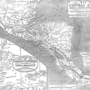
Photographic Print : Map of Mexico, 1902. Creator: Unknown


![]()
Photo Prints from Heritage Images
Map of Mexico, 1902. Creator: Unknown
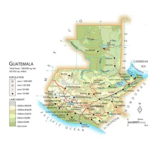
Map of Mexico, 1902. Showing Guatemala and British Honduras, with inset of Mexico City. From The Century Atlas of the World. [John Walker & Co, Ltd. London, 1902]
Heritage Images features heritage image collections
Media ID 15512458
© The Print Collector / Heritage-Images
Central America Edinburgh Geographical Institute Guatemala Mexico Belize British Honduras
10"x8" Photo Print
Step back in time with our vintage Map of Mexico print from the Media Storehouse collection. This beautiful, antique map, dating back to 1902, showcases the geography of Mexico during an intriguing era. Detailed and intricately designed, this map highlights the regions of Guatemala and British Honduras, with an inset of Mexico City from The Century Atlas of the World, published by John Walker & Co, Ltd. in London. Add an air of historical charm to your home or office decor with this captivating, unknown creator piece from Heritage Images.
Photo prints are produced on Kodak professional photo paper resulting in timeless and breath-taking prints which are also ideal for framing. The colors produced are rich and vivid, with accurate blacks and pristine whites, resulting in prints that are truly timeless and magnificent. Whether you're looking to display your prints in your home, office, or gallery, our range of photographic prints are sure to impress. Dimensions refers to the size of the paper in inches.
Our Photo Prints are in a large range of sizes and are printed on Archival Quality Paper for excellent colour reproduction and longevity. They are ideal for framing (our Framed Prints use these) at a reasonable cost. Alternatives include cheaper Poster Prints and higher quality Fine Art Paper, the choice of which is largely dependant on your budget.
Estimated Image Size (if not cropped) is 25.4cm x 18.1cm (10" x 7.1")
Estimated Product Size is 25.4cm x 20.3cm (10" x 8")
These are individually made so all sizes are approximate
Artwork printed orientated as per the preview above, with landscape (horizontal) orientation to match the source image.
FEATURES IN THESE COLLECTIONS
> Europe
> United Kingdom
> Scotland
> Edinburgh
> Edinburgh
> Europe
> United Kingdom
> Scotland
> Lothian
> Edinburgh
> Maps and Charts
> Related Images
> Maps and Charts
> World
> North America
> Belize
> Belize City
> North America
> Belize
> Maps
> North America
> Belize
> Related Images
> North America
> Guatemala
> Guatemala City
> North America
> Guatemala
> Maps
EDITORS COMMENTS
This print showcases a Map of Mexico from the year 1902, with Guatemala and British Honduras (now Belize) also depicted. The creator of this intricate map remains unknown, adding an air of mystery to its historical significance. From "The Century Atlas of the World" published by John Walker & Co in London, this map offers a glimpse into the geopolitical landscape of Central America during the early 20th century. With vibrant colors and precise detailing, this print highlights various cities and regions within Mexico, including an inset specifically dedicated to Mexico City. Produced by the Edinburgh Geographical Institute, renowned for their cartographic expertise at that time, this map is not only visually appealing but also serves as a valuable resource for understanding the country's geography. Beyond its aesthetic appeal lies a deeper exploration into the history and cultural heritage of Mexico. This print allows us to trace back how borders have shifted over time and provides insights into neighboring countries such as Guatemala and British Honduras (Belize). As we examine this piece closely, it becomes evident that maps hold immense power in unraveling stories about our past. Preserved by The Print Collector - a trusted source for historical prints - this image invites us to reflect on how our world has evolved since 1902 while appreciating the craftsmanship involved in creating such detailed maps. It serves as both a reminder of our shared history and an inspiration for future explorations.
MADE IN THE USA
Safe Shipping with 30 Day Money Back Guarantee
FREE PERSONALISATION*
We are proud to offer a range of customisation features including Personalised Captions, Color Filters and Picture Zoom Tools
SECURE PAYMENTS
We happily accept a wide range of payment options so you can pay for the things you need in the way that is most convenient for you
* Options may vary by product and licensing agreement. Zoomed Pictures can be adjusted in the Cart.