Photographic Print > Europe > United Kingdom > Scotland > Edinburgh > Edinburgh
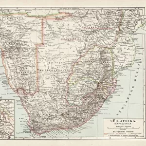
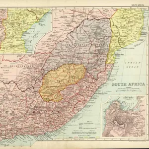
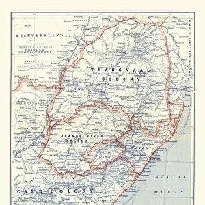
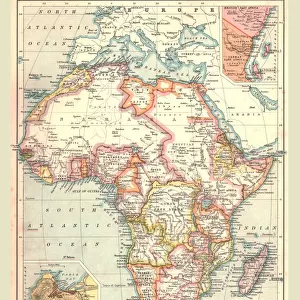
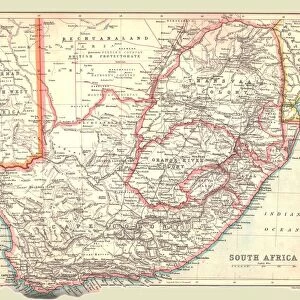
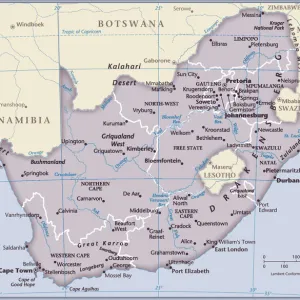
Photographic Print : General Map of British South Africa, 1900. Creator: Unknown


![]()
Photo Prints From Heritage Images
General Map of British South Africa, 1900. Creator: Unknown
General Map of British South Africa, 1900. From " South Africa and the Transvaal War, Vol. I", by Louis Creswicke. [T. C. & E. C. Jack, Edinburgh, 1900]
Heritage Images features heritage image collections
Media ID 19780675
© The Print Collector/Heritage Images
Cartography Creswicke Jack Louis Louis Creswicke Map Making Mapmaking South Africa South Africa And The Transvaal War Tc And Ec Tc And Ec Jack British Empire
10"x8" Photo Print
Discover the historical depth of the past with our exquisite collection of vintage maps from Media Storehouse. This particular print showcases a General Map of British South Africa from the year 1900. Originally published in "South Africa and the Transvaal War, Vol. I" by Louis Creswicke, this map provides a fascinating insight into the geographical landscape and political boundaries of the region during that time. With intricate details and an authentic, aged appearance, this print is not just a decorative piece, but a window into history. Uncover the stories of the past and add a touch of historical charm to your home or office with our Media Storehouse range of Photographic Prints.
Photo prints are produced on Kodak professional photo paper resulting in timeless and breath-taking prints which are also ideal for framing. The colors produced are rich and vivid, with accurate blacks and pristine whites, resulting in prints that are truly timeless and magnificent. Whether you're looking to display your prints in your home, office, or gallery, our range of photographic prints are sure to impress. Dimensions refers to the size of the paper in inches.
Our Photo Prints are in a large range of sizes and are printed on Archival Quality Paper for excellent colour reproduction and longevity. They are ideal for framing (our Framed Prints use these) at a reasonable cost. Alternatives include cheaper Poster Prints and higher quality Fine Art Paper, the choice of which is largely dependant on your budget.
Estimated Product Size is 20.3cm x 25.4cm (8" x 10")
These are individually made so all sizes are approximate
Artwork printed orientated as per the preview above, with portrait (vertical) orientation to match the source image.
FEATURES IN THESE COLLECTIONS
> Africa
> South Africa
> Maps
> Africa
> South Africa
> Related Images
> Arts
> Literature
> Illustration
> Arts
> Literature
> Europe
> United Kingdom
> Scotland
> Edinburgh
> Edinburgh
> Europe
> United Kingdom
> Scotland
> Lothian
> Edinburgh
> Maps and Charts
> British Empire Maps
> Maps and Charts
> Related Images
EDITORS COMMENTS
This print showcases a piece of history frozen in time - the "General Map of British South Africa, 1900". Created by an unknown artist, this map is a remarkable representation of the African continent during the colonial era. It was featured in Louis Creswicke's renowned book "South Africa and the Transvaal War, Vol. I", published by T. C. & E. C. Jack in Edinburgh in 1900. The map provides a comprehensive view of South Africa, highlighting its diverse geography and intricate cartography. It serves as a testament to the British Empire's influence on the region during that period, reflecting their colonial ambitions and territorial control. As we delve into this image, we are transported back to the late 19th century when exploration and colonization were at their peak. The artistry behind this illustration demonstrates meticulous attention to detail and precision in mapmaking techniques prevalent at that time. This print not only captures an important historical artifact but also represents a significant contribution to literature on African geography. Its presence evokes curiosity about how maps like these shaped perceptions of nations and territories within both academic circles and popular culture. Preserved by The Print Collector, this visual treasure allows us to appreciate the rich heritage of South Africa while contemplating its complex past marked by imperialism and colonialism.
MADE IN THE USA
Safe Shipping with 30 Day Money Back Guarantee
FREE PERSONALISATION*
We are proud to offer a range of customisation features including Personalised Captions, Color Filters and Picture Zoom Tools
SECURE PAYMENTS
We happily accept a wide range of payment options so you can pay for the things you need in the way that is most convenient for you
* Options may vary by product and licensing agreement. Zoomed Pictures can be adjusted in the Basket.