Photographic Print > Arts > Landscape paintings > Waterfall and river artworks > River artworks
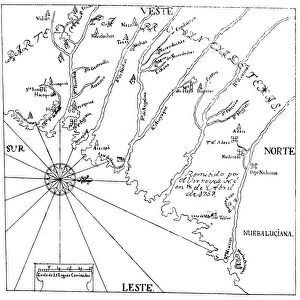
Photographic Print : MAP: UNITED STATES, 1849. A General Map of the United States with the contiguous


![]()
Photo Prints From Granger
MAP: UNITED STATES, 1849. A General Map of the United States with the contiguous
MAP: UNITED STATES, 1849.
A General Map of the United States with the contiguous British & Mexican Possessions: engraved map published, 1849, by Samuel A. Mitchell at Philadelphia
Granger holds millions of images spanning more than 25,000 years of world history, from before the Stone Age to the dawn of the Space Age
Media ID 12321050
1849 Canada Latin America Mesoamerica Mexico United States
10"x8" Photo Print
Discover history through the lens with our Media Storehouse range of Photographic Prints. This captivating antique map, "MAP: UNITED STATES, 1849," transports you back in time. Engraved in 1849 by Samuel A. Mitchell at Philadelphia, this detailed map showcases the United States as it was known during that era, including the British and Mexican possessions. Each print is meticulously produced using high-quality photographic processes, ensuring brilliant colors and exceptional detail. Bring this piece of history into your home or office and add an intriguing conversation starter to your space. Order your Media Storehouse Photographic Print of "MAP: UNITED STATES, 1849" today and embark on a journey through the annals of time. #VintageMap #HistoricalPrint #AmericanHistory
Photo prints are produced on Kodak professional photo paper resulting in timeless and breath-taking prints which are also ideal for framing. The colors produced are rich and vivid, with accurate blacks and pristine whites, resulting in prints that are truly timeless and magnificent. Whether you're looking to display your prints in your home, office, or gallery, our range of photographic prints are sure to impress. Dimensions refers to the size of the paper in inches.
Our Photo Prints are in a large range of sizes and are printed on Archival Quality Paper for excellent colour reproduction and longevity. They are ideal for framing (our Framed Prints use these) at a reasonable cost. Alternatives include cheaper Poster Prints and higher quality Fine Art Paper, the choice of which is largely dependant on your budget.
Estimated Product Size is 25.4cm x 20.3cm (10" x 8")
These are individually made so all sizes are approximate
Artwork printed orientated as per the preview above, with landscape (horizontal) or portrait (vertical) orientation to match the source image.
FEATURES IN THESE COLLECTIONS
> Granger Art on Demand
> Maps
> Arts
> Landscape paintings
> Waterfall and river artworks
> River artworks
> Maps and Charts
> Related Images
> North America
> Canada
> Maps
> North America
> Canada
> Related Images
> North America
> Mexico
> Maps
> North America
> Mexico
> Related Images
EDITORS COMMENTS
This print showcases a historical treasure, the "MAP: UNITED STATES, 1849". It is a remarkable representation of the United States during that era, meticulously engraved by Samuel A. Mitchell and published in Philadelphia in 1849. The map encompasses not only the contiguous states but also provides insight into the British and Mexican possessions at that time. As we delve into this piece of art, it transports us back to an important period in American history. With its intricate details and precise cartography, this map offers a glimpse into the vastness of America's expansion during the mid-19th century. From coast to coast, it captures every state with utmost accuracy. Beyond just depicting borders and territories, this map serves as a visual testament to America's influence on its neighboring regions. It highlights Canada to the north and various Latin American countries to the south, including Mexico and Mesoamerica. The inclusion of major rivers further enhances our understanding of how these waterways played crucial roles in shaping transportation routes and trade networks across different parts of America. Through this print from Granger Art on Demand, viewers can appreciate both the artistic beauty and historical significance encapsulated within this exquisite engraving. Whether you are an avid historian or simply intrigued by maps' ability to tell stories about our past, "MAP: UNITED STATES, 1849" is sure to captivate your imagination for hours on end.
MADE IN THE USA
Safe Shipping with 30 Day Money Back Guarantee
FREE PERSONALISATION*
We are proud to offer a range of customisation features including Personalised Captions, Color Filters and Picture Zoom Tools
SECURE PAYMENTS
We happily accept a wide range of payment options so you can pay for the things you need in the way that is most convenient for you
* Options may vary by product and licensing agreement. Zoomed Pictures can be adjusted in the Basket.