Photographic Print > Animals > Mammals > Muridae > Western Mouse
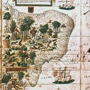
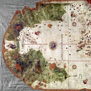
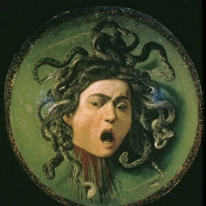
Photographic Print : CANTINO WORLD MAP, 1502. Western half of the Cantino map of the world

![]()
Photo Prints from Granger
CANTINO WORLD MAP, 1502. Western half of the Cantino map of the world
CANTINO WORLD MAP, 1502. Western half of the Cantino map of the world, 1502, showing (at left) the Tordesillas Treaty demarcation line of 1494 which divided the non-Christian (i.e. undiscovered) world between Spain and Portugal
Granger holds millions of images spanning more than 25,000 years of world history, from before the Stone Age to the dawn of the Space Age
Media ID 6622241
1502 Age Of Discovery New World Portolan Chart Portugal Portuguese Spain Spanish Topography World
10"x10" Photo Print
Introducing the Media Storehouse range of Photographic Prints featuring the fascinating "Cantino World Map, 1502. Western half of the Cantino Map of the World" from The Granger Collection. This captivating image showcases the Western half of the rare and historical Cantino Map, created in 1502. The map is renowned for its intricate detail and accuracy, offering a unique glimpse into the world as it was understood during the early 16th century. The map includes the Tordesillas Treaty demarcation line of 1494, which marked the division of the non-Christian world between Spain and Portugal. Bring a piece of history into your home or office with this stunning, high-quality photographic print. Perfect for avid history enthusiasts, cartographers, or anyone with an appreciation for the beauty and intrigue of ancient maps. Order yours today and let this mesmerizing image transport you back in time.
Photo prints are produced on Kodak professional photo paper resulting in timeless and breath-taking prints which are also ideal for framing. The colors produced are rich and vivid, with accurate blacks and pristine whites, resulting in prints that are truly timeless and magnificent. Whether you're looking to display your prints in your home, office, or gallery, our range of photographic prints are sure to impress. Dimensions refers to the size of the paper in inches.
Our Photo Prints are in a large range of sizes and are printed on Archival Quality Paper for excellent colour reproduction and longevity. They are ideal for framing (our Framed Prints use these) at a reasonable cost. Alternatives include cheaper Poster Prints and higher quality Fine Art Paper, the choice of which is largely dependant on your budget.
Estimated Image Size (if not cropped) is 25.4cm x 24.1cm (10" x 9.5")
Estimated Product Size is 25.4cm x 25.4cm (10" x 10")
These are individually made so all sizes are approximate
Artwork printed orientated as per the preview above, with landscape (horizontal) orientation to match the source image.
FEATURES IN THESE COLLECTIONS
> Granger Art on Demand
> Maps
> Animals
> Mammals
> Muridae
> Western Mouse
> Arts
> Art Movements
> Renaissance Art
> Europe
> Portugal
> Related Images
> Europe
> Spain
> Related Images
EDITORS COMMENTS
This print showcases the remarkable "CANTINO WORLD MAP, 1502" specifically focusing on its western half. Created during the Renaissance period, this masterpiece offers a glimpse into the Age of Discovery and the exploration of new lands by Portuguese and Spanish navigators. The highlight of this image is undoubtedly the Tordesillas Treaty demarcation line of 1494, prominently displayed at the left side. This historic agreement divided the yet-to-be-discovered non-Christian world between Spain and Portugal, marking their respective territories in uncharted waters. With intricate details and precision, this portolan chart provides an extraordinary topographical representation of both known and unknown regions. It serves as a testament to the incredible advancements made in cartography during that era. As we delve into this mesmerizing artwork, we are transported back in time to an age filled with curiosity and ambition. The Cantino map not only reflects Europe's thirst for exploration but also encapsulates their desire to expand their empires across distant horizons. This Granger Collection print allows us to appreciate not only its historical significance but also its artistic beauty. It serves as a reminder of humanity's relentless pursuit of knowledge and discovery throughout history.
MADE IN THE USA
Safe Shipping with 30 Day Money Back Guarantee
FREE PERSONALISATION*
We are proud to offer a range of customisation features including Personalised Captions, Color Filters and Picture Zoom Tools
SECURE PAYMENTS
We happily accept a wide range of payment options so you can pay for the things you need in the way that is most convenient for you
* Options may vary by product and licensing agreement. Zoomed Pictures can be adjusted in the Cart.