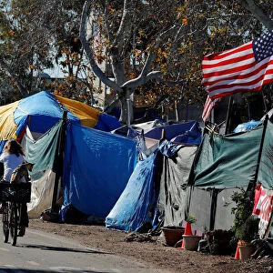
Photographic Print > North America > United States of America > California > San Diego
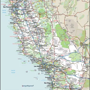
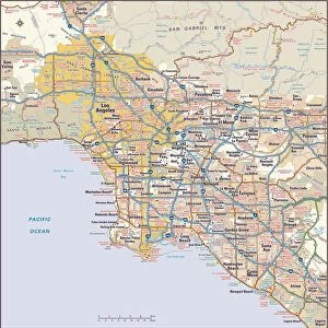
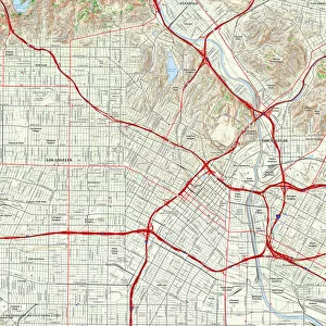
Photographic Print : MAP: LOS ANGELES, 1800s. Important historical events which have made Los Angeles


![]()
Photo Prints From Granger
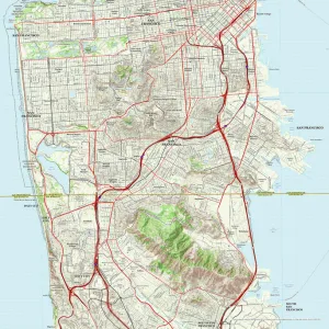
MAP: LOS ANGELES, 1800s. Important historical events which have made Los Angeles
MAP: LOS ANGELES, 1800s.
Important historical events which have made Los Angeles growth possible. Lithograph, c1929
Granger holds millions of images spanning more than 25,000 years of world history, from before the Stone Age to the dawn of the Space Age
Media ID 13641758
1800s 1849 1851 1869 California Central Pacific Railroad Gold Rush Los Angeles Mountain Pacific Ocean Pony Express Railroad San Diego San Francisco Stage Coach Westward Expansion Rancho
10"x8" Photo Print
Step back in time with our vintage Map: Los Angeles, 1800s print from Granger, NYC / The Granger Collection. This intriguing lithograph, produced in 1929, showcases the historical milestones that shaped the growth of Los Angeles. Witness the transformation of the city as you explore key events from the 1800s. A captivating addition to any home or office, this print is not just a map but a window into the rich history of this iconic city. Order now from Granger Art on Demand and bring a piece of the past into your present.
Photo prints are produced on Kodak professional photo paper resulting in timeless and breath-taking prints which are also ideal for framing. The colors produced are rich and vivid, with accurate blacks and pristine whites, resulting in prints that are truly timeless and magnificent. Whether you're looking to display your prints in your home, office, or gallery, our range of photographic prints are sure to impress. Dimensions refers to the size of the paper in inches.
Our Photo Prints are in a large range of sizes and are printed on Archival Quality Paper for excellent colour reproduction and longevity. They are ideal for framing (our Framed Prints use these) at a reasonable cost. Alternatives include cheaper Poster Prints and higher quality Fine Art Paper, the choice of which is largely dependant on your budget.
Estimated Product Size is 20.3cm x 25.4cm (8" x 10")
These are individually made so all sizes are approximate
Artwork printed orientated as per the preview above, with landscape (horizontal) or portrait (vertical) orientation to match the source image.
FEATURES IN THESE COLLECTIONS
> Animals
> Mammals
> Cricetidae
> California Mouse
> Arts
> Artists
> O
> Oceanic Oceanic
> Maps and Charts
> Early Maps
> Maps and Charts
> Related Images
> North America
> United States of America
> California
> Los Angeles
> North America
> United States of America
> California
> San Diego
> North America
> United States of America
> California
> San Francisco
EDITORS COMMENTS
This print showcases a historical map of Los Angeles in the 1800s, shedding light on the important events that shaped its growth. The lithograph, dating back to around 1929, offers a glimpse into the city's rich history and highlights key milestones that propelled Los Angeles forward. The image takes us on a journey through time, starting with significant moments like the California Gold Rush of 1849. This event brought droves of fortune seekers to the region, triggering an economic boom and setting the stage for future development. Another pivotal occurrence depicted is the completion of the Central Pacific Railroad in 1869. This monumental feat connected Los Angeles to San Francisco and other major cities along the West Coast, facilitating trade and transportation. As we explore further within this intricate illustration, we discover references to various modes of travel prevalent during that era: from stage coaches traversing rugged mountain terrain to Pony Express riders galloping across vast distances. These methods played vital roles in connecting different regions and fostering communication. Additionally, glimpses of iconic landmarks such as Rancho San Diego and Pacific Ocean serve as reminders of Los Angeles' natural beauty and geographical significance. Overall, this remarkable print captures not only a visual representation but also tells stories about how these historical events paved the way for Los Angeles' growth into one of America's most vibrant cities today.
MADE IN THE USA
Safe Shipping with 30 Day Money Back Guarantee
FREE PERSONALISATION*
We are proud to offer a range of customisation features including Personalised Captions, Color Filters and Picture Zoom Tools
SECURE PAYMENTS
We happily accept a wide range of payment options so you can pay for the things you need in the way that is most convenient for you
* Options may vary by product and licensing agreement. Zoomed Pictures can be adjusted in the Basket.