Photographic Print > North America > United States of America > New York > New York > Maps
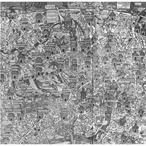
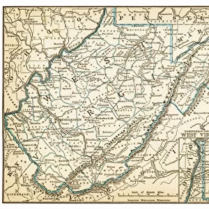
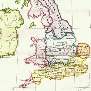
Photographic Print : Historical map of New York City, USA, lithograph, published 1897


![]()
Photo Prints from Fine Art Storehouse
Historical map of New York City, USA, lithograph, published 1897
Historical city map of New York City, USA. Lithograph, published in 1897
Unleash your creativity and transform your space into a visual masterpiece!
ZU_09
Media ID 18106831
10"x8" Photo Print
Step back in time with our exquisite Historical Map of New York City print from the Media Storehouse Fine Art collection. This stunning lithograph, published in 1897, offers a captivating glimpse into the past with intricate details of the city's layout during an era of significant growth and transformation. The rich, vibrant colors and intricate lines of this ZU_09 creation bring history to life, making it a must-have addition to any home or office space. Transport yourself back to the late 19th century and indulge in the beauty and history of New York City.
Photo prints are produced on Kodak professional photo paper resulting in timeless and breath-taking prints which are also ideal for framing. The colors produced are rich and vivid, with accurate blacks and pristine whites, resulting in prints that are truly timeless and magnificent. Whether you're looking to display your prints in your home, office, or gallery, our range of photographic prints are sure to impress. Dimensions refers to the size of the paper in inches.
Our Photo Prints are in a large range of sizes and are printed on Archival Quality Paper for excellent colour reproduction and longevity. They are ideal for framing (our Framed Prints use these) at a reasonable cost. Alternatives include cheaper Poster Prints and higher quality Fine Art Paper, the choice of which is largely dependant on your budget.
Estimated Product Size is 20.3cm x 25.4cm (8" x 10")
These are individually made so all sizes are approximate
Artwork printed orientated as per the preview above, with portrait (vertical) orientation to match the source image.
FEATURES IN THESE COLLECTIONS
> Fine Art Storehouse
> Map
> Historical Maps
> Fine Art Storehouse
> Map
> USA Maps
> Maps and Charts
> Early Maps
> Maps and Charts
> Related Images
> North America
> United States of America
> Maps
> North America
> United States of America
> New York
> New York
> Maps
> North America
> United States of America
> New York
> Related Images
EDITORS COMMENTS
This print takes us back in time to the bustling streets of New York City, USA, as it stood in 1897. A true treasure for history enthusiasts and urban explorers alike, this lithograph offers a glimpse into the city's rich past. The intricate details and artistic rendering of this historical map transport us to an era when horse-drawn carriages traversed cobblestone roads and towering buildings began to shape the iconic skyline we know today. Every corner of this meticulously crafted lithograph tells a story - from the winding paths of Central Park to the vibrant neighborhoods that define each borough. As our eyes wander across its surface, we can almost hear the echoes of street vendors hawking their wares or catch a whiff of freshly baked bread wafting from local bakeries. The artist behind this remarkable piece, ZU_09, has masterfully captured not only the physical layout but also the essence and spirit of New York City during its formative years. With every stroke of ink on paper, they have immortalized a moment frozen in time – an invaluable resource for historians seeking insights into how this metropolis evolved over centuries. Whether you are a native New Yorker longing for nostalgia or simply fascinated by urban development throughout history, this historical map serves as both an educational tool and a stunning work of art. It invites us to explore every inch with curiosity and wonderment while reminding us that beneath layers of progress lies a city steeped in heritage waiting to be discovered anew.
MADE IN THE USA
Safe Shipping with 30 Day Money Back Guarantee
FREE PERSONALISATION*
We are proud to offer a range of customisation features including Personalised Captions, Color Filters and Picture Zoom Tools
SECURE PAYMENTS
We happily accept a wide range of payment options so you can pay for the things you need in the way that is most convenient for you
* Options may vary by product and licensing agreement. Zoomed Pictures can be adjusted in the Cart.