Photographic Print > North America > United States of America > Massachusetts > Worcester
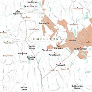
Photographic Print : MA Worcester Athol Vector Road Map

![]()
Photo Prints From Fine Art Storehouse
MA Worcester Athol Vector Road Map
MA Worcester Athol Vector Road Map. All source data is in the public domain. U.S. Census Bureau Census Tiger. Used Layers: areawater, linearwater, roads, rails, cousub, pointlm, uac10
Unleash your creativity and transform your space into a visual masterpiece!
Frank Ramspott
Media ID 20692321
© Frank Ramspott, all rights reserved
City Map Computer Graphic County Digital Composite District Geographical Border Massachusetts Orange Road Map Text Vector Worcester Athol Digitally Generated Image Pinedale
10"x10" Photo Print
Discover the unique blend of art and cartography with the MA Worcester Athol Vector Road Map print from Media Storehouse, part of our Fine Art Storehouse collection. Created by Frank Ramspott, this stunning piece transforms the data from the U.S. Census Bureau into a captivating work of art. With intricate details showcasing the roads, rails, waterways, and points of interest in Worcester, Athol, MA, this print is perfect for those who appreciate the beauty of maps and the history of their community. Each print is produced using high-quality materials and techniques to bring out the vibrant colors and intricate details of the original vector design. Add a touch of intellectual and artistic flair to your home or office decor with this one-of-a-kind map print.
Photo prints are produced on Kodak professional photo paper resulting in timeless and breath-taking prints which are also ideal for framing. The colors produced are rich and vivid, with accurate blacks and pristine whites, resulting in prints that are truly timeless and magnificent. Whether you're looking to display your prints in your home, office, or gallery, our range of photographic prints are sure to impress. Dimensions refers to the size of the paper in inches.
Our Photo Prints are in a large range of sizes and are printed on Archival Quality Paper for excellent colour reproduction and longevity. They are ideal for framing (our Framed Prints use these) at a reasonable cost. Alternatives include cheaper Poster Prints and higher quality Fine Art Paper, the choice of which is largely dependant on your budget.
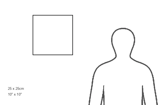
Estimated Product Size is 25.4cm x 25.4cm (10" x 10")
These are individually made so all sizes are approximate
Artwork printed orientated as per the preview above, with landscape (horizontal) or portrait (vertical) orientation to match the source image.
FEATURES IN THESE COLLECTIONS
> Fine Art Storehouse
> Map
> Reference Maps
> Animals
> Mammals
> Bovidae
> Sheep
> Animals
> Mammals
> Cats (Wild)
> Tiger
> Arts
> Contemporary art
> Digital artwork
> Street art
> Arts
> Street art graffiti
> Digital art
> Digital paintings
> Maps and Charts
> Related Images
> North America
> United States of America
> Massachusetts
> Worcester
> Popular Themes
> Lake District
> Popular Themes
> Sheep
EDITORS COMMENTS
This vibrant and detailed print showcases the MA Worcester Athol Vector Road Map, a stunning piece of cartography designed by Frank Ramspott. With all source data obtained from the public domain, including U. S. Census Bureau Census Tiger information, this map is an accurate representation of the geographical features in Massachusetts. The image depicts various layers such as areawater, linearwater, roads, rails, cousub, pointlm, and uac10 to provide a comprehensive overview of the region's physical geography. The digitally generated design beautifully combines colors and vectors to create an eye-catching visual composition. While there are no people featured in this photograph, it serves as a valuable resource for anyone seeking to explore or navigate through Worcester Athol and its surrounding areas. The map highlights important landmarks like rivers, lakes, cities such as Partridgeville and Orange, as well as notable hills like Kelton Hill and Pratt Hill. With its intricate details and precise boundaries demarcating different districts within Massachusetts county lines - this print is perfect for those interested in studying or appreciating cartography. It represents a fusion of artistry with computer graphics resulting in a captivating digital composite that will surely enhance any space it adorns
MADE IN THE USA
Safe Shipping with 30 Day Money Back Guarantee
FREE PERSONALISATION*
We are proud to offer a range of customisation features including Personalised Captions, Color Filters and Picture Zoom Tools
SECURE PAYMENTS
We happily accept a wide range of payment options so you can pay for the things you need in the way that is most convenient for you
* Options may vary by product and licensing agreement. Zoomed Pictures can be adjusted in the Basket.