Photographic Print > Europe > France > Maps
Photographic Print : France country map


Photo Prints From Fine Art Storehouse
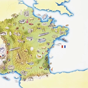
France country map
2011 edition
Unleash your creativity and transform your space into a visual masterpiece!
Media ID 14432127
10"x8" Photo Print
Photo prints are produced on Kodak professional photo paper resulting in timeless and breath-taking prints which are also ideal for framing. The colors produced are rich and vivid, with accurate blacks and pristine whites, resulting in prints that are truly timeless and magnificent. Whether you're looking to display your prints in your home, office, or gallery, our range of photographic prints are sure to impress. Dimensions refers to the size of the paper in inches.
Our Photo Prints are in a large range of sizes and are printed on Archival Quality Paper for excellent colour reproduction and longevity. They are ideal for framing (our Framed Prints use these) at a reasonable cost. Alternatives include cheaper Poster Prints and higher quality Fine Art Paper, the choice of which is largely dependant on your budget.
Estimated Product Size is 20.3cm x 25.4cm (8" x 10")
These are individually made so all sizes are approximate
Artwork printed orientated as per the preview above, with landscape (horizontal) or portrait (vertical) orientation to match the source image.
FEATURES IN THESE COLLECTIONS
> Fine Art Storehouse
> Map
> Reference Maps
> Fine Art Storehouse
> Top Sellers - Art Prints
> Maps and Charts
> Related Images
EDITORS COMMENTS
This stunning print showcases the intricate details of France's country map, specifically the 2011 edition. With its vibrant colors and precise cartographic lines, this artwork from Fine Art Storehouse is a true masterpiece that captures the essence of this beautiful European nation. The map depicts France's diverse landscapes, from the snow-capped peaks of the Alps to the picturesque vineyards of Bordeaux. It highlights major cities like Paris, Lyon, and Marseille, as well as smaller towns and villages that dot the countryside. The intricate network of rivers and lakes are intricately portrayed, showcasing France's rich water resources. Every inch of this print invites exploration and discovery. Whether you're planning a trip or simply fascinated by geography, this piece will transport you to every corner of France without leaving your home. Its detailed representation allows for an immersive experience as you trace your finger along winding roads or imagine strolling through historic streets. Hang it in your living room or office space to spark conversations about travel adventures or ignite memories from past visits to this enchanting country. This artwork serves not only as an aesthetic addition but also as a source of inspiration for wanderlust souls who yearn to explore all that France has to offer.
MADE IN THE USA
Safe Shipping with 30 Day Money Back Guarantee
FREE PERSONALISATION*
We are proud to offer a range of customisation features including Personalised Captions, Color Filters and Picture Zoom Tools
SECURE PAYMENTS
We happily accept a wide range of payment options so you can pay for the things you need in the way that is most convenient for you
* Options may vary by product and licensing agreement. Zoomed Pictures can be adjusted in the Basket.