Photographic Print > Europe > France > Paris > Maps
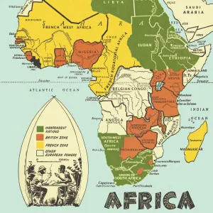
Photographic Print : North and South America map 1887


![]()
Photo Prints From Fine Art Storehouse
North and South America map 1887
Map from La Premiere Annee de Geographie par P. Foncin - Paris 1887
Unleash your creativity and transform your space into a visual masterpiece!
THEPALMER
Media ID 20773117
© A 2014 Roberto Adrian Photography
10"x8" Photo Print
Step back in time with our exquisite 'North and South America Map 1887' print from ThePalmer's collection at Media Storehouse. This fine art reproduction, taken from the first year edition of 'La Premiere Annee de Geographie' by P. Foncin in Paris (1887), offers a captivating glimpse into the historical cartography of the Americas. With intricate detail and authentic antique charm, this vintage map print makes a stunning addition to any home or office decor. Bring history to life and transport yourself on a journey through time with this beautiful piece from our Fine Art Storehouse.
Photo prints are produced on Kodak professional photo paper resulting in timeless and breath-taking prints which are also ideal for framing. The colors produced are rich and vivid, with accurate blacks and pristine whites, resulting in prints that are truly timeless and magnificent. Whether you're looking to display your prints in your home, office, or gallery, our range of photographic prints are sure to impress. Dimensions refers to the size of the paper in inches.
Our Photo Prints are in a large range of sizes and are printed on Archival Quality Paper for excellent colour reproduction and longevity. They are ideal for framing (our Framed Prints use these) at a reasonable cost. Alternatives include cheaper Poster Prints and higher quality Fine Art Paper, the choice of which is largely dependant on your budget.
Estimated Product Size is 20.3cm x 25.4cm (8" x 10")
These are individually made so all sizes are approximate
Artwork printed orientated as per the preview above, with landscape (horizontal) or portrait (vertical) orientation to match the source image.
FEATURES IN THESE COLLECTIONS
> Europe
> France
> Paris
> Maps
> Maps and Charts
> Related Images
EDITORS COMMENTS
This print showcases a historical gem, the North and South America map from 1887. Taken from "La Premiere Annee de Geographie par P. Foncin - Paris 1887" this exquisite piece of cartography offers a glimpse into the past, allowing us to marvel at how our understanding of the world has evolved over time. The intricate details and vibrant colors of this map are truly mesmerizing. Every contour, river, and mountain range is meticulously depicted, reflecting the dedication and skill of its creator. As we gaze upon this masterpiece, we can't help but feel a sense of wonderment at the vastness and diversity that these two continents possess. Transporting us back in time to an era when exploration was still unfolding, this print serves as a reminder of humanity's insatiable curiosity about our planet. It sparks our imagination with thoughts of intrepid explorers venturing into uncharted territories in search of new discoveries. "ThePALMER" has expertly captured every nuance in this photograph; it feels as if we are holding an authentic relic from history itself. The fine art storehouse has done justice to preserving such an invaluable piece for future generations to appreciate. Whether you're a history enthusiast or simply captivated by the beauty found within maps, this print will undoubtedly become a cherished addition to any collection. Let it transport you on an enchanting journey through time as you explore the rich tapestry that is North and South America in 1887.
MADE IN THE USA
Safe Shipping with 30 Day Money Back Guarantee
FREE PERSONALISATION*
We are proud to offer a range of customisation features including Personalised Captions, Color Filters and Picture Zoom Tools
SECURE PAYMENTS
We happily accept a wide range of payment options so you can pay for the things you need in the way that is most convenient for you
* Options may vary by product and licensing agreement. Zoomed Pictures can be adjusted in the Basket.