Photographic Print > Asia > Israel > Jerusalem Heritage Sites > Old City of Jerusalem and its Walls
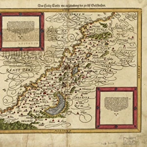
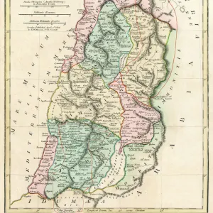
Photographic Print : Map of Palestine and Jerusalem, lithograph, published in 1881

![]()
Photo Prints from Fine Art Storehouse
Map of Palestine and Jerusalem, lithograph, published in 1881
Detailed topographic map of Palestine and Jerusalem. Facsimile from my archive, published in 1881
Unleash your creativity and transform your space into a visual masterpiece!
ZU_09
Media ID 23824037
© ZU_09
Canaan Valley Historical Palestine Israel Israelite Jerusalem Jerusalem Old City Judaism Land Nation State Topographic Map Topography
11"x8.5" Photo Print
Step back in time with our exquisite reproduction of a historic map from the Media Storehouse range. This beautifully detailed topographic map of Palestine and Jerusalem, published in 1881, offers a fascinating glimpse into the past. Meticulously crafted from a lithograph originally created over a century ago, this facsimile print by ZU_09 from Fine Art Storehouse transports you to a bygone era. Ideal for history enthusiasts, educators, and collectors, this map is not only a captivating piece of art but also a valuable addition to your home or office decor. Bring history to life with this authentic and intricately detailed reproduction.
Photo prints are produced on Kodak professional photo paper resulting in timeless and breath-taking prints which are also ideal for framing. The colors produced are rich and vivid, with accurate blacks and pristine whites, resulting in prints that are truly timeless and magnificent. Whether you're looking to display your prints in your home, office, or gallery, our range of photographic prints are sure to impress. Dimensions refers to the size of the paper in inches.
Our Photo Prints are in a large range of sizes and are printed on Archival Quality Paper for excellent colour reproduction and longevity. They are ideal for framing (our Framed Prints use these) at a reasonable cost. Alternatives include cheaper Poster Prints and higher quality Fine Art Paper, the choice of which is largely dependant on your budget.
Estimated Image Size (if not cropped) is 18.2cm x 27.9cm (7.2" x 11")
Estimated Product Size is 21.6cm x 27.9cm (8.5" x 11")
These are individually made so all sizes are approximate
Artwork printed orientated as per the preview above, with portrait (vertical) orientation to match the source image.
FEATURES IN THESE COLLECTIONS
> Arts
> Photorealistic artworks
> Detailed art pieces
> Masterful detailing in art
> Asia
> Israel
> Jerusalem Heritage Sites
> Old City of Jerusalem and its Walls
> Asia
> Israel
> Related Images
> Asia
> Palestine
> Jerusalem
> Asia
> Palestine
> Related Images
> Europe
> France
> Canton
> Landes
> Maps and Charts
> Early Maps
EDITORS COMMENTS
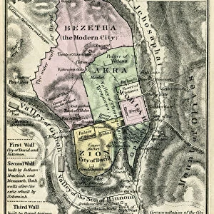
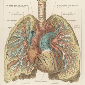
This lithograph, titled "Map of Palestine and Jerusalem" takes us back in time to the year 1881. A remarkable piece of cartography, it offers a detailed topographic representation of historical Palestine and Jerusalem. This particular print is a facsimile from an archive, ensuring its authenticity and preserving its significance. The map showcases the intricate landscape of Canaan Valley, capturing every contour with precision. It allows us to explore the ancient land that holds immense historical importance for various civilizations throughout centuries. From Israelite settlements to significant landmarks associated with Judaism, this map provides a comprehensive understanding of the region's rich heritage. One cannot help but be drawn to the magnificence of Jerusalem depicted within this lithograph. The old city stands prominently at its center, surrounded by walls that have witnessed countless stories unfold over time. Its narrow streets wind through historic neighborhoods while leading towards iconic sites like the Western Wall and Temple Mount. As we delve into this meticulously crafted artwork, we are reminded not only of geographical boundaries but also of nations and states that have left their mark on these lands throughout history. This map serves as a testament to typographers' skill in accurately representing such complex terrain. ZU_09's print invites us to appreciate both the beauty and historical significance embedded within this topographic masterpiece. It transports us back in time while reminding us how our world has evolved since then – making it an invaluable addition for any admirer or scholar interested in exploring Palestine's past or studying cartography's evolution
MADE IN THE USA
Safe Shipping with 30 Day Money Back Guarantee
FREE PERSONALISATION*
We are proud to offer a range of customisation features including Personalised Captions, Color Filters and Picture Zoom Tools
SECURE PAYMENTS
We happily accept a wide range of payment options so you can pay for the things you need in the way that is most convenient for you
* Options may vary by product and licensing agreement. Zoomed Pictures can be adjusted in the Cart.