Photographic Print > Maps and Charts > Related Images
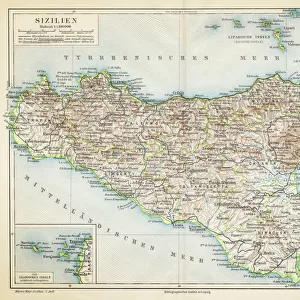
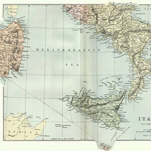
Photographic Print : Sardinia and Sicily map 1896


![]()
Photo Prints From Fine Art Storehouse
Sardinia and Sicily map 1896
Andres Allgemeiner Handatlas - Bielefeld und Leipzig 1896
Unleash your creativity and transform your space into a visual masterpiece!
THEPALMER
Media ID 18356789
12"x8" Photo Print
Step back in time with our exquisite 'Sardinia and Sicily Map 1896' photographic print from ThePalmer at Media Storehouse. This stunning collectible piece, taken from the Andres Allgemeiner Handatlas published in Bielefeld and Leipzig in 1896, transports you to a bygone era. The intricate details of the map, with its bold lines and meticulous annotations, offer a captivating glimpse into the historical cartography of the Mediterranean. Ideal for history enthusiasts, world travelers, or anyone seeking a unique and thoughtful addition to their home or office decor, this vintage map print is a must-have for those who appreciate the beauty and richness of the past.
Photo prints are produced on Kodak professional photo paper resulting in timeless and breath-taking prints which are also ideal for framing. The colors produced are rich and vivid, with accurate blacks and pristine whites, resulting in prints that are truly timeless and magnificent. Whether you're looking to display your prints in your home, office, or gallery, our range of photographic prints are sure to impress. Dimensions refers to the size of the paper in inches.
Our Photo Prints are in a large range of sizes and are printed on Archival Quality Paper for excellent colour reproduction and longevity. They are ideal for framing (our Framed Prints use these) at a reasonable cost. Alternatives include cheaper Poster Prints and higher quality Fine Art Paper, the choice of which is largely dependant on your budget.
Estimated Product Size is 30.5cm x 20.3cm (12" x 8")
These are individually made so all sizes are approximate
Artwork printed orientated as per the preview above, with landscape (horizontal) orientation to match the source image.
FEATURES IN THESE COLLECTIONS
> Europe
> Italy
> Sardinia
> Related Images
> Europe
> Italy
> Sicily
> Related Images
> Maps and Charts
> Related Images
EDITORS COMMENTS
This print showcases a historic map of Sardinia and Sicily from 1896, taken from Andres Allgemeiner Handatlas - Bielefeld und Leipzig. With intricate details and exquisite craftsmanship, this piece offers a glimpse into the past, inviting us to explore the rich geography of these Mediterranean islands. The map itself is a testament to the artistry and precision of cartography in the late 19th century. Every contour, river, and coastline is meticulously rendered with utmost accuracy, reflecting the dedication and expertise of its creator. The delicate color palette adds an elegant touch to this vintage masterpiece, enhancing its allure as both a work of art and historical documentation. As we gaze upon this print by THEPALMER from Fine Art Storehouse, we are transported back in time to an era when maps were not just navigational tools but also works of beauty that captured our imagination. It serves as a reminder that even in today's digital age, there is still something enchanting about holding a physical representation of our world in our hands. Whether you have an appreciation for history or simply admire fine art prints, this Sardinia and Sicily map will undoubtedly be a striking addition to any collection or decor. Its timeless charm transcends generations while offering endless opportunities for exploration within its intricate contours.
MADE IN THE USA
Safe Shipping with 30 Day Money Back Guarantee
FREE PERSONALISATION*
We are proud to offer a range of customisation features including Personalised Captions, Color Filters and Picture Zoom Tools
SECURE PAYMENTS
We happily accept a wide range of payment options so you can pay for the things you need in the way that is most convenient for you
* Options may vary by product and licensing agreement. Zoomed Pictures can be adjusted in the Basket.