Photographic Print > Maps and Charts > Related Images
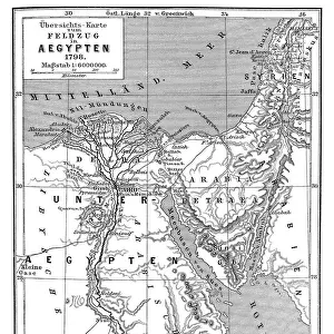
Photographic Print : Peoples map of the earth from 19th century

![]()
Photo Prints from Fine Art Storehouse
Peoples map of the earth from 19th century
Illustration of a Peoples map of the earth from 19th century
Unleash your creativity and transform your space into a visual masterpiece!
Nastasic
Media ID 18433959
11"x8.5" Photo Print
Step back in time with our exquisite Peoples Map of the Earth print from the Media Storehouse Fine Art collection. This captivating 19th-century map, created by Nastasic, offers a unique and intriguing perspective of the world as it was once known. Delve into the history of cartography as you admire the distinct representations of various ethnic groups and territories. Bring this piece of historical artistry into your home or office to spark curiosity and inspire conversation among your guests. Experience the past in vibrant detail, order your Peoples Map of the Earth print today.
Photo prints are produced on Kodak professional photo paper resulting in timeless and breath-taking prints which are also ideal for framing. The colors produced are rich and vivid, with accurate blacks and pristine whites, resulting in prints that are truly timeless and magnificent. Whether you're looking to display your prints in your home, office, or gallery, our range of photographic prints are sure to impress. Dimensions refers to the size of the paper in inches.
Our Photo Prints are in a large range of sizes and are printed on Archival Quality Paper for excellent colour reproduction and longevity. They are ideal for framing (our Framed Prints use these) at a reasonable cost. Alternatives include cheaper Poster Prints and higher quality Fine Art Paper, the choice of which is largely dependant on your budget.
Estimated Image Size (if not cropped) is 27.9cm x 18.9cm (11" x 7.4")
Estimated Product Size is 27.9cm x 21.6cm (11" x 8.5")
These are individually made so all sizes are approximate
Artwork printed orientated as per the preview above, with landscape (horizontal) orientation to match the source image.
FEATURES IN THESE COLLECTIONS
> Fine Art Storehouse
> Map
> Historical Maps
> Maps and Charts
> Related Images
EDITORS COMMENTS
This print showcases an exquisite illustration of a Peoples map of the earth from the 19th century. Created by the talented artist Nastasic, this piece takes us on a journey back in time to explore how people perceived and understood our planet during that era. The intricate details and vibrant colors of this artwork transport us to a world where cartography was still evolving. The map is adorned with delicate drawings, depicting various cultures, landmarks, and natural wonders across different continents. It offers a fascinating glimpse into the diverse societies and civilizations that inhabited our Earth centuries ago. As we gaze upon this remarkable print, we can't help but marvel at the level of craftsmanship displayed by Nastasic. Each stroke seems purposeful, carefully capturing not only geographical features but also cultural nuances unique to each region depicted. This image serves as a reminder of how far humanity has come in terms of exploration and understanding our planet's vastness. It sparks curiosity about what has changed since then while igniting appreciation for those who paved the way for modern geography. Whether you are an art enthusiast or history buff, this print will undoubtedly captivate your imagination and transport you to an era when maps were not just tools for navigation but gateways to discovery.
MADE IN THE USA
Safe Shipping with 30 Day Money Back Guarantee
FREE PERSONALISATION*
We are proud to offer a range of customisation features including Personalised Captions, Color Filters and Picture Zoom Tools
SECURE PAYMENTS
We happily accept a wide range of payment options so you can pay for the things you need in the way that is most convenient for you
* Options may vary by product and licensing agreement. Zoomed Pictures can be adjusted in the Cart.