Photographic Print > Maps and Charts > Related Images
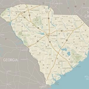
Photographic Print : Map of South Carolina 1894

![]()
Photo Prints from Fine Art Storehouse
Map of South Carolina 1894
Map of South Carolina
Unleash your creativity and transform your space into a visual masterpiece!
THEPALMER
Media ID 20114793
© Roberto A Sanchez
11"x8.5" Photo Print
Discover the rich history of South Carolina with our stunningly detailed Map of South Carolina 1894 print from THEPALMER's Fine Art Storehouse collection. This intricately designed map transports you back in time, showcasing the borders, counties, and major landmarks of South Carolina as they appeared over a century ago. Each print is meticulously crafted using high-quality materials and vibrant colors, ensuring a beautiful addition to any home or office space. Bring a piece of the past into your present with this exquisite work of art.
Photo prints are produced on Kodak professional photo paper resulting in timeless and breath-taking prints which are also ideal for framing. The colors produced are rich and vivid, with accurate blacks and pristine whites, resulting in prints that are truly timeless and magnificent. Whether you're looking to display your prints in your home, office, or gallery, our range of photographic prints are sure to impress. Dimensions refers to the size of the paper in inches.
Our Photo Prints are in a large range of sizes and are printed on Archival Quality Paper for excellent colour reproduction and longevity. They are ideal for framing (our Framed Prints use these) at a reasonable cost. Alternatives include cheaper Poster Prints and higher quality Fine Art Paper, the choice of which is largely dependant on your budget.
Estimated Image Size (if not cropped) is 27.9cm x 18.1cm (11" x 7.1")
Estimated Product Size is 27.9cm x 21.6cm (11" x 8.5")
These are individually made so all sizes are approximate
Artwork printed orientated as per the preview above, with landscape (horizontal) orientation to match the source image.
FEATURES IN THESE COLLECTIONS
> Fine Art Storehouse
> Map
> Historical Maps
> Maps and Charts
> Related Images
EDITORS COMMENTS
In this print titled "Map of South Carolina 1894" we are transported back in time to a bygone era, where cartography was an art form and engraved images were the epitome of precision. Created by THEPALMER, this exquisite piece showcases the intricate details and craftsmanship that went into mapping the physical geography of South Carolina. As our eyes wander across the aged paper, we are immersed in a world where technology had not yet taken over, leaving us with a sense of nostalgia for simpler times. The delicate engravings etched onto the map reveal every contour and feature of this beautiful southern state. The Map of South Carolina 1894 is more than just an obsolete representation; it serves as a window into history. It reminds us of how far we have come in terms of exploration and understanding our surroundings. Each line tells a story - from rivers meandering through lush landscapes to towns dotting the countryside like hidden gems waiting to be discovered. This print captures not only the essence of cartography but also evokes a sense of wonderment about what life was like during that period. It invites us to appreciate both the artistry behind creating such maps and their practical significance in guiding explorers, settlers, and travelers alike. "The Map of South Carolina 1894" is truly a testament to human ingenuity and curiosity about our world's physical makeup – an enchanting piece that will transport any viewer on an imaginary journey through time.
MADE IN THE USA
Safe Shipping with 30 Day Money Back Guarantee
FREE PERSONALISATION*
We are proud to offer a range of customisation features including Personalised Captions, Color Filters and Picture Zoom Tools
SECURE PAYMENTS
We happily accept a wide range of payment options so you can pay for the things you need in the way that is most convenient for you
* Options may vary by product and licensing agreement. Zoomed Pictures can be adjusted in the Cart.