Photographic Print > North America > United States of America > New York > Related Images
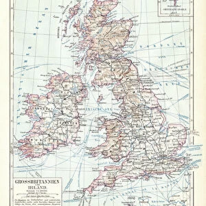
Photographic Print : British isles map 1881


![]()
Photo Prints From Fine Art Storehouse
British isles map 1881
Harpers School Geography, New York, Harpers and Brothers, 1881
Unleash your creativity and transform your space into a visual masterpiece!
THEPALMER
Media ID 14756110
© This content is subject to copyright
Great Britain Ireland Scotland
10"x8" Photo Print
Step back in time with our exquisite 'British Isles Map 1881' photographic print from ThePalmer at Fine Art Storehouse. This captivating piece takes you on a journey to an era of historical significance, showcasing intricate detail from the Harpers School Geography book published by Harpers and Brothers in New York in 1881. Each print is meticulously crafted to preserve the authenticity and charm of this classic map, making it a unique addition to your home or office decor. Immerse yourself in history and add a touch of timeless elegance to your space with ThePalmer's 'British Isles Map 1881' print.
Photo prints are produced on Kodak professional photo paper resulting in timeless and breath-taking prints which are also ideal for framing. The colors produced are rich and vivid, with accurate blacks and pristine whites, resulting in prints that are truly timeless and magnificent. Whether you're looking to display your prints in your home, office, or gallery, our range of photographic prints are sure to impress. Dimensions refers to the size of the paper in inches.
Our Photo Prints are in a large range of sizes and are printed on Archival Quality Paper for excellent colour reproduction and longevity. They are ideal for framing (our Framed Prints use these) at a reasonable cost. Alternatives include cheaper Poster Prints and higher quality Fine Art Paper, the choice of which is largely dependant on your budget.
Estimated Product Size is 20.3cm x 25.4cm (8" x 10")
These are individually made so all sizes are approximate
Artwork printed orientated as per the preview above, with portrait (vertical) orientation to match the source image.
EDITORS COMMENTS
This print showcases a vintage map of the British Isles, dating back to 1881. A true treasure from Harpers School Geography in New York, published by Harpers and Brothers, this piece takes us on a journey through time. The intricate details and delicate lines beautifully depict Great Britain, Ireland, Scotland, and the United Kingdom as they were over a century ago. The map's historical significance is undeniable; it offers an invaluable glimpse into the past, allowing us to explore the geography of these iconic lands during that era. As we gaze upon this artwork by THEPALMER from Fine Art Storehouse, we are transported back to a time when borders were different and nations had distinct identities. The craftsmanship evident in every stroke is awe-inspiring. Each contour reflects meticulous cartographic precision while capturing the essence of these remarkable islands. This print serves as both an educational tool for geography enthusiasts and an exquisite decorative piece for any space. Whether displayed in a classroom or adorning the walls of your home or office, this photograph invites you to immerse yourself in history while appreciating its aesthetic beauty. It sparks curiosity about how landscapes have evolved throughout time and encourages contemplation on our connection with the past. THEPALMER's attention to detail brings out every nuance of this antique map—making it not just a visual delight but also an invitation to explore centuries-old stories etched onto paper.
MADE IN THE USA
Safe Shipping with 30 Day Money Back Guarantee
FREE PERSONALISATION*
We are proud to offer a range of customisation features including Personalised Captions, Color Filters and Picture Zoom Tools
SECURE PAYMENTS
We happily accept a wide range of payment options so you can pay for the things you need in the way that is most convenient for you
* Options may vary by product and licensing agreement. Zoomed Pictures can be adjusted in the Basket.